
Portal:Caribbean
| Main Portal page | Indices | Projects |
 |
 |

| |
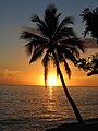
The Caribbean (/ˌkærɪˈbiːən, kəˈrɪbiən/ KARR-ih-BEE-ən, kə-RIB-ee-ən, locally /ˈkærɪbiːæn/ KARR-ih-bee-an; Spanish: el Caribe; French: les Caraïbes; Dutch: de Caraïben) is a subregion of the Americas that includes the Caribbean Sea and its islands, some of which are surrounded by the Caribbean Sea and some of which border both the Caribbean Sea and the North Atlantic Ocean; the nearby coastal areas on the mainland are sometimes also included in the region. The region is south-east of the Gulf of Mexico and Northern America, east of Central America, and north of South America.
Situated largely on the Caribbean Plate, the region has more than 700 islands, islets, reefs, and cays. Island arcs delineate the northern and eastern edges of the Caribbean Sea: the Greater Antilles in the north and the Lesser Antilles, which includes the Leeward Antilles, in the east and south. The nearby Lucayan Archipelago, comprising The Bahamas and the Turks and Caicos Islands, is considered to be a part of the Caribbean despite not bordering the Caribbean Sea. All the islands in the Antilles plus the Lucayan Archipelago form the West Indies, which is often interchangeable with the term Caribbean. On the mainland, Belize, the eastern and northern coasts of Central and South American countries such as the Bay Islands Department of Honduras, the North and South Caribbean Autonomous Regions of Nicaragua, the Limón Province of Costa Rica, and the Archipelago of San Andrés, Providencia and Santa Catalina of Colombia are also considered culturally Caribbean. French Guiana, Guyana, Panama, and Suriname are often included as parts of the Caribbean due to their political and cultural ties with the region.
Geopolitically, the islands of the Caribbean are often regarded as a subregion of North America, though sometimes they are included in Middle America or left as a subregion of their own; alternately, the term "Caribbean" may have the intended exclusion, or even unintentional inclusion, as part of Latin America. Generally the Caribbean area is organized into 33 political entities, including 13 sovereign states, 12 dependencies, historical disputed territories have existed, and seven other overseas territories. From 15 December 1954 to 10 October 2010, there was a territory known as the Netherlands Antilles composed of five islands, all of which were Dutch dependencies. From 3 January 1958 to 31 May 1962, there was also a short-lived political union called the British West Indies Federation composed of ten English-speaking Caribbean territories, all of which were then British dependencies. (Full article...)
 Good article -

In early July 2005, Hurricane Dennis brushed Jamaica, bringing torrential rain and damaging floods to the island nation. Forming from a tropical depression on July 4, Dennis began impacting Jamaica three days later. Approximately 6,000 people evacuated from coastal and flood-prone areas prior to the storm's arrival while relief agencies allocated resources for recovery operations. Passing northeast of the island, impact from Dennis stemmed primarily from rainfall—accumulations peaked at 24.54 in (623 mm) and reached 1-in-50 year event levels. Widespread flooding and landslides damaged homes and isolated communities. Saint Thomas and Portland Parishes were hardest-hit; hundreds required evacuation as multiple rivers burst their banks.
Overall, 209,000 people were affected with 6,000 households requesting assistance. A week after Dennis, Hurricane Emily brought further rain to the island, exacerbating damage. Their combined effects damaged or destroyed 440 homes with total losses reaching J$5.976 billion (US$96.87 million), of which at least J$2.128 billion (US$34.5 million) can be attributed to Dennis alone. One person died due to flooding. Relief operations began before the hurricane subsided, and international communities provided further aid. The overall effects of Dennis were limited and the nation's economy sustained no major ramifications. (Full article...)Selected geography article -

Martinique (/ˌmɑːrtɪˈniːk/ MAR-tin-EEK, French: [maʁtinik] ; Martinican Creole: Matinik or Matnik; Kalinago: Madinina or Madiana) is an island in the Lesser Antilles of the West Indies, in the eastern Caribbean Sea. A part of the French West Indies (Antilles), Martinique is an overseas department and region and a single territorial collectivity of the French Republic. It is a part of the European Union as an outermost region within the special territories of members of the European Economic Area, and an associate member of the CARICOM, but is not part of the Schengen Area or the European Union Customs Union. The currency in use is the euro.
Martinique has a land area of 1,128 km2 (436 sq mi) and a population of 349,925 inhabitants as of January 2024. One of the Windward Islands, it lies directly north of Saint Lucia, northwest of Barbados and south of Dominica. Virtually the entire population speaks both French (the sole official language) and Martinican Creole. (Full article...)Selected fare or cuisine -

Habichuelas con dulce is a sweet bean liquid dessert from the Dominican Republic that is especially popular around the Easter holiday. The dessert is part of the cuisine of the Dominican Republic and is traditionally garnished with milk cookies or with casabe, "a flatbread made of yuca flour."
Habichuelas con dulce is made with red beans, cinnamon, nutmeg, coconut milk, evaporated milk, raisins, sugar and salt. The beans are boiled with cinnamon sticks and sweet cloves and then blended to the consistency of soup. The coconut milk and evaporated milk are added along with cooked sweet potato chunks. Cloves and ginger can also be added as flavorings. (Full article...)Did you know? -
- ...that the Soufrière Hills volcano is an active complex stratovolcano with many lava domes forming its summit on the Caribbean island of Montserrat?
- ...that Operation Verano was the name given to a summer offensive in 1958 by forces acting for President Fulgencio Batista, against rebels led by Fidel Castro during the Cuban Revolution?
- ...that Trenchtown, a neighbourhood in Kingston, Jamaica, gets its name from a large open-trenched sewer that ran through the neighbourhood?
Related portals
Wikiproject
 Featured article -

Hurricane Hazel was the deadliest, second-costliest, and most intense hurricane of the 1954 Atlantic hurricane season. The storm killed at least 469 people in Haiti before it struck the United States near the border between North and South Carolina as a Category 4 hurricane. After causing 95 fatalities in the US, Hazel struck Canada as an extratropical storm, which raised the death toll by 81 people, mostly in Toronto. As a result of the high death toll and the damage caused by Hazel, its name was retired from use for North Atlantic hurricanes.
In Haiti, Hazel destroyed 40 percent of the coffee trees and 50 percent of the cacao crop, which affected the economy for several years. The hurricane made landfall near Calabash, North Carolina, and destroyed most waterfront dwellings. It then traveled north along the Atlantic coast. Hazel affected Virginia; Washington, D.C.; West Virginia; Maryland; Delaware; New Jersey; Pennsylvania; and New York. It brought gusts near 160 km/h (100 mph) and caused $281 million (1954 USD) in damage. When it was over Pennsylvania, Hazel consolidated with a cold front and turned northwest towards Canada. When it hit Ontario as an extratropical storm, rivers and streams in and around Toronto overflowed their banks, which caused severe flooding. As a result, many residential areas in the local floodplains, such as the Raymore Drive area, were subsequently converted to parkland. In Canada alone, over C$135 million (2023: C$1.5 billion) of damage was incurred. (Full article...)Selected image -

Steelband in Port of Spain, Trinidad, in the early 1950s.
Selected music -
The music of the former Netherlands Antilles is a mixture of native, African and European elements, and is closely connected with trends from neighboring countries such as Venezuela and Colombia and islands such as Puerto Rico, Cuba, Santo Domingo, Haiti, Martinique, Trinidad, Dominica, and Guadeloupe. The former Netherlands Antilles islands of Curaçao and Aruba are known for their typical waltzes, danzas, mazurkas and a kind of music called tumba, which is named after the conga drums that accompany it.
The remaining islands are much smaller than Aruba, Bonaire, and Curaçao. They are Sint Eustatius, Sint Maarten and Saba. Sint Eustatius has little nightlife, with only one nightclub (the zouk Largo Height Disco) as of 1996. The inhabitants, "Statians", hold impromptu street dances called "road blocks", using booming car stereos. Saba has a number of dances at various restaurants, including a wide variety of hip hop, calypso, soca, kompa, zouk, bouyon, reggae and merengue. Sint Maarten has a well-known Carnival tradition featuring music and dance, held in mid-April and culminating in the traditional burning of King Moui-Moui, as well as a number of nightclubs and casinos featuring music; popular "spots" where locals go to dance include Boo Boo Jam and Lago Height, both located on the northern (French) part of Sint Maarten; the most popular recent casino band is King Bo-Bo, known as the "King of Calypso". (Full article...)General images
-
 A container ship docked in the deep water harbour of Bridgetown, Barbados, which opened in 1961. (from History of the Caribbean)
 -
 Sir Ralph Abercromby, Commander of the British forces that captured Trinidad and Tobago. (from History of the Caribbean)
 -
-
 Contemporary political map of the Caribbean (from History of the Caribbean)
 -
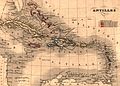 Map of Antilles / Caribbean in 1843. (from History of the Caribbean)
 -
 A carriage on a street in Martinique, one of the Caribbean islands that has not become independent. It is an overseas region of France, and its citizens are full French citizens. (from History of the Caribbean)
 -
 Illustration circa 1815 showing "Incendie du Cap" (Burning of Cape Francais) during the Haitian Revolution. The caption reads: "General revolt of the Blacks. Massacre of the Whites". (from History of the Caribbean)
 -
 The Piazza (or main square) in central Havana, Cuba, in 1762, during the Seven Years' War. (from History of the Caribbean)
 -
 The forced African migrants brought to the Caribbean lived in inhumane conditions. Above are examples of slave huts in Dutch Bonaire. About 5 feet tall and 6 feet wide, between 2 and 3 slaves slept in these after working in nearby salt mines. (from History of the Caribbean)
 -
 A linen market in the British West Indies, circa 1780 (from History of the Caribbean)
 -
 A 19th-century lithograph by Theodore Bray showing a sugarcane plantation. On right is "white officer", the European overseer, surveilling plantation workers. To the left is a flat-bottomed vessel for cane transportation. (from History of the Caribbean)
 -
 United States' rescue effort at St. Vincent, 1902, following an eruption of the volcano at La Soufrière. (from History of the Caribbean)
 -
 Linguistic map of the Caribbean in CE 1500, before European colonization (from History of the Caribbean)
 -
 A medallion showing the Capture of Trinidad and Tobago by the British in 1797. (from History of the Caribbean)
 -
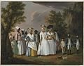 Agostino Brunias. Free Women of Color with Their Children and Servants in a Landscape, ca. 1770-1796 Brooklyn Museum (from Culture of the Caribbean)
 -
 Political evolution of Central America and the Caribbean from 1700 to present (from History of the Caribbean)
 -
-
 A 1906 advertisement in the Montreal Medical Journal, showing the United Fruit Company selling trips to Jamaica. (from History of the Caribbean)
 -
 Bath Hotel, Nevis, photograph by Jose Anjo of Antigua (from Tourism in Latin America and the Caribbean)
 -
 Spanish Caribbean Islands in the American Viceroyalties 1600. (from History of the Caribbean)
 -
 The Natives of Cumaná attack the mission after Gonzalo de Ocampo's slaving raid. Colored copperplate by Theodor de Bry, published in the "Relación brevissima de la destruccion de las Indias". (from History of the Caribbean)
 -
 Crane Resort old and new buildings, Cobblers Reef, Barbados (from Tourism in Latin America and the Caribbean)
 -

-
 American 757 on final approach to Saint Maarten Airport (from Tourism in Latin America and the Caribbean)
 -
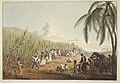
 Cane cutters in Jamaica, 1880s. (from History of the Caribbean)
 -
 Battle of the Saintes by Thomas Mitchell. This 1782 battle between the British and French navies took place near Guadeloupe. (from History of the Caribbean)


.jpg)


,_plate_IV_-_BL.jpg)


Caribbean topics
Categories

New articles
Rules | Match log | Results page (for watching) | Last updated: 2024-05-24 19:51 (UTC)
Note: The list display can now be customized by each user. See List display personalization for details.
- Latin American wars of independence (edit | talk | history | links | watch | logs | tools) by AHI-3000 (talk · contribs · new pages (26)) started on 2024-05-24, score: 16
- 1961 Salvadoran coup d'état (edit | talk | history | links | watch | logs | tools) by TheBrowniess (talk · contribs · new pages (19)) started on 2024-05-24, score: 16
- El Laguito Cigar Factory (edit | talk | history | links | watch | logs | tools) by EssNS (talk · contribs · new pages (31)) started on 2024-05-24, score: 24
- Pakistan women's cricket team in England and Ireland in 2012 (edit | talk | history | links | watch | logs | tools) by Hey man im josh (talk · contribs · new pages (323)) started on 2024-05-24, score: 16
- He Knows (Camila Cabello song) (edit | talk | history | links | watch | logs | tools) by 2600:6C50:7EF0:71E0:A9A9:4471:80C2:7BB4 (talk · contribs · new pages (1)) started on 2024-05-24, score: 16
- Jeffrey Baltus (edit | talk | history | links | watch | logs | tools) by Das osmnezz (talk · contribs · new pages (66)) started on 2024-05-24, score: 16
- 2021 Punjab Kings season (edit | talk | history | links | watch | logs | tools) by Sammi Brie (talk · contribs · new pages (136)) started on 2024-05-24, score: 16
- 2021 Kolkata Knight Riders season (edit | talk | history | links | watch | logs | tools) by Sammi Brie (talk · contribs · new pages (136)) started on 2024-05-24, score: 16
- 2019 Kolkata Knight Riders season (edit | talk | history | links | watch | logs | tools) by Sammi Brie (talk · contribs · new pages (136)) started on 2024-05-24, score: 24
- List of Kappa Beta Pi chapters (edit | talk | history | links | watch | logs | tools) by Rublamb (talk · contribs · new pages (14)) started on 2024-05-24, score: 16
- 2024 World Judo Championships – Mixed team (edit | talk | history | links | watch | logs | tools) by UHShe4Life (talk · contribs · new pages (1)) started on 2024-05-24, score: 16
- Moonlight Benjamin (edit | talk | history | links | watch | logs | tools) by NotGuyFieri (talk · contribs · new pages (1)) started on 2024-05-24, score: 16
- Lenny Tavárez (edit | talk | history | links | watch | logs | tools) by Sebaspikyaq (talk · contribs · new pages (13)) started on 2024-05-24, score: 16
- Eastern Caribbean-Southeast Asia Chamber (edit | talk | history | links | watch | logs | tools) by Bulklana (talk · contribs · new pages (1)) started on 2024-05-23, score: 16
- List of alumni of Hatfield College, Durham (edit | talk | history | links | watch | logs | tools) by Leonstojka (talk · contribs · new pages (1)) started on 2024-05-23, score: 16
- Caribbean batfish (edit | talk | history | links | watch | logs | tools) by CycoMa1 (talk · contribs · new pages (16)) started on 2024-05-19, score: 27
- 2024–25 NCAA Division I men's basketball season (edit | talk | history | links | watch | logs | tools) by Robert McClenon (talk · contribs · new pages (21)) started on 2024-05-19, score: 24
- 2023 Rolling Stone en Español Awards (edit | talk | history | links | watch | logs | tools) by JuliánLeiva66 (talk · contribs · new pages (2)) started on 2024-05-23, score: 24
- 1998 FIFA World Cup qualification – CONCACAF third round (edit | talk | history | links | watch | logs | tools) by Wburrow (talk · contribs · new pages (1)) started on 2024-05-23, score: 40
- Mary Young Sewell (edit | talk | history | links | watch | logs | tools) by Gamaliel (talk · contribs · new pages (44)) started on 2024-05-23, score: 16
- La Conga (nightclub) (edit | talk | history | links | watch | logs | tools) by EssNS (talk · contribs · new pages (31)) started on 2024-05-23, score: 16
- July 2024 Sint Maarten general election (edit | talk | history | links | watch | logs | tools) by Number 57 (talk · contribs · new pages (7)) started on 2024-05-22, score: 19
- List of eulipotyphlans (edit | talk | history | links | watch | logs | tools) by PresN (talk · contribs · new pages (5)) started on 2024-05-22, score: 24
- Michel Météry (edit | talk | history | links | watch | logs | tools) by GMoulard (talk · contribs · new pages (2)) started on 2024-05-22, score: 16
- 2024 Porsche Sprint Challenge Great Britain (edit | talk | history | links | watch | logs | tools) by RxxingAddict (talk · contribs · new pages (1)) started on 2024-05-22, score: 16
- Disney Destiny (ship) (edit | talk | history | links | watch | logs | tools) by CANthony0125 (talk · contribs · new pages (13)) started on 2024-05-22, score: 16
- Dick Steinborn (edit | talk | history | links | watch | logs | tools) by Kingzwest (talk · contribs · new pages (2)) started on 2024-05-22, score: 24
- Arubus N.V. (edit | talk | history | links | watch | logs | tools) by Sadfun43! (talk · contribs · new pages (1)) started on 2024-05-22, score: 16
- Naomi Seymour (edit | talk | history | links | watch | logs | tools) by Moondragon21 (talk · contribs · new pages (60)) started on 2024-05-21, score: 16
- 2024 New Caledonia unrest (edit | talk | history | links | watch | logs | tools) by Moondragon21 (talk · contribs · new pages (60)) started on 2024-05-14, score: 24
- Caribbean Fragoza (edit | talk | history | links | watch | logs | tools) by Bustedtype888 (talk · contribs · new pages (14)) started on 2024-05-21, score: 16
- La Ranger (edit | talk | history | links | watch | logs | tools) by Sebaspikyaq (talk · contribs · new pages (13)) started on 2024-05-21, score: 16
- Wrecks of Saint-Pierre harbor (edit | talk | history | links | watch | logs | tools) by GMoulard (talk · contribs · new pages (2)) started on 2024-05-21, score: 32
- Statue of Roberto Clemente (New York City) (edit | talk | history | links | watch | logs | tools) by Omnis Scientia (talk · contribs · new pages (35)) started on 2024-05-21, score: 16
- 21st Lima Film Festival (edit | talk | history | links | watch | logs | tools) by Renknight (talk · contribs · new pages (10)) started on 2024-05-21, score: 16
- Ipomoea setosa (edit | talk | history | links | watch | logs | tools) by WelwitschiaTokarev (talk · contribs · new pages (2)) started on 2024-05-21, score: 16
- Taíno genocide (edit | talk | history | links | watch | logs | tools) by Borboteo (talk · contribs · new pages (14)) started on 2024-05-21, score: 48
- 2024 Little League World Series (edit | talk | history | links | watch | logs | tools) by Stan394 (talk · contribs · new pages (2)) started on 2024-05-20, score: 24
- 2024 Little League World Series qualification (edit | talk | history | links | watch | logs | tools) by Stan394 (talk · contribs · new pages (2)) started on 2024-05-20, score: 56
- 22nd Lima Film Festival (edit | talk | history | links | watch | logs | tools) by Renknight (talk · contribs · new pages (10)) started on 2024-05-20, score: 24
- MICAL (Bahamas Parliament constituency) (edit | talk | history | links | watch | logs | tools) by Moondragon21 (talk · contribs · new pages (60)) started on 2024-05-20, score: 16
- Halieutichthys caribbaeus (edit | talk | history | links | watch | logs | tools) by CycoMa1 (talk · contribs · new pages (16)) started on 2024-05-19, score: 32
- Toki (song) (edit | talk | history | links | watch | logs | tools) by 222 Goshiy (talk · contribs · new pages (2)) started on 2024-05-14, score: 24
- Johnathan Rodríguez (edit | talk | history | links | watch | logs | tools) by Muboshgu (talk · contribs · new pages (11)) started on 2024-05-20, score: 16
- Sam T. Taylor (edit | talk | history | links | watch | logs | tools) by Jeffrey Beall (talk · contribs · new pages (4)) started on 2024-05-20, score: 16
- Casimiro Antonio Marte Familia (edit | talk | history | links | watch | logs | tools) by IntergalacticOboist (talk · contribs · new pages (5)) started on 2024-05-20, score: 24
- Montserrat Casas (edit | talk | history | links | watch | logs | tools) by Alsoriano97 (talk · contribs · new pages (1)) started on 2024-05-20, score: 16
- Tizzy (edit | talk | history | links | watch | logs | tools) by Clarityfiend (talk · contribs · new pages (8)) started on 2024-05-20, score: 16
- Che Simmons (edit | talk | history | links | watch | logs | tools) by Hildreth gazzard (talk · contribs · new pages (187)) started on 2024-05-20, score: 24
- Wilfred Benítez vs. Roberto Durán (edit | talk | history | links | watch | logs | tools) by Beast from da East (talk · contribs · new pages (6)) started on 2024-05-20, score: 16
- George J. Gmelch (edit | talk | history | links | watch | logs | tools) by SL93 (talk · contribs · new pages (33)) started on 2024-05-20, score: 16
- Morfina (edit | talk | history | links | watch | logs | tools) by DominicanWikiEdit1996 (talk · contribs · new pages (2)) started on 2024-05-20, score: 16
- Revelation Pt. 2 – The Fruit of Life (edit | talk | history | links | watch | logs | tools) by L to the K (talk · contribs · new pages (3)) started on 2024-05-20, score: 16
- Moenck & Quintana (edit | talk | history | links | watch | logs | tools) by EssNS (talk · contribs · new pages (31)) started on 2024-05-19, score: 16
- Aymeric Priam (edit | talk | history | links | watch | logs | tools) by Hildreth gazzard (talk · contribs · new pages (187)) started on 2024-05-19, score: 24
- Heritage Collection Museum (edit | talk | history | links | watch | logs | tools) by LittleT889 (talk · contribs · new pages (5)) started on 2024-05-19, score: 24
- Ideoblothrus curazavius (edit | talk | history | links | watch | logs | tools) by WhatIsAPoggers (talk · contribs · new pages (8)) started on 2024-05-17, score: 27
- Jump (Tyla, Gunna, and Skillibeng song) (edit | talk | history | links | watch | logs | tools) by Qaqaamba (talk · contribs · new pages (2)) started on 2024-05-15, score: 24
- Frederick Snare (edit | talk | history | links | watch | logs | tools) by EssNS (talk · contribs · new pages (31)) started on 2024-05-19, score: 16
- Theresa Miskimen (edit | talk | history | links | watch | logs | tools) by TJMSmith (talk · contribs · new pages (17)) started on 2024-05-19, score: 16
- Rashtrakutas (edit | talk | history | links | watch | logs | tools) by BilledMammal (talk · contribs · new pages (169)) started on 2024-05-19, score: 16
- Miguel Ángel Moenck (edit | talk | history | links | watch | logs | tools) by EssNS (talk · contribs · new pages (31)) started on 2024-05-19, score: 16
- World Masters League T20 (edit | talk | history | links | watch | logs | tools) by Clearfrienda (talk · contribs · new pages (37)) started on 2024-05-19, score: 16
- Príamo Tejeda (edit | talk | history | links | watch | logs | tools) by Gianlu2790 (talk · contribs · new pages (3)) started on 2024-05-19, score: 16
- Nicolás Quintana (edit | talk | history | links | watch | logs | tools) by EssNS (talk · contribs · new pages (31)) started on 2024-05-19, score: 32
- Nicolás Quintana Arango (edit | talk | history | links | watch | logs | tools) by EssNS (talk · contribs · new pages (31)) started on 2024-05-19, score: 16
- Tonight (Black Eyed Peas and El Alfa song) (edit | talk | history | links | watch | logs | tools) by Monika Helgesson (talk · contribs · new pages (1)) started on 2024-05-19, score: 16
- King Tubby Meets Vivian Jackson (edit | talk | history | links | watch | logs | tools) by GanzKnusper (talk · contribs · new pages (9)) started on 2024-05-19, score: 16
- When Magic Hurts (edit | talk | history | links | watch | logs | tools) by Abskiee (talk · contribs · new pages (7)) started on 2024-05-19, score: 16
- Tease Me (album) (edit | talk | history | links | watch | logs | tools) by Hiddenstranger (talk · contribs · new pages (8)) started on 2024-05-19, score: 16
- Drew Thomas (edit | talk | history | links | watch | logs | tools) by Cunard (talk · contribs · new pages (2)) started on 2024-05-19, score: 16
- Club Atenas (edit | talk | history | links | watch | logs | tools) by EssNS (talk · contribs · new pages (31)) started on 2024-05-18, score: 16
- Valentin Medrano Pérez (edit | talk | history | links | watch | logs | tools) by IntergalacticOboist (talk · contribs · new pages (5)) started on 2024-05-18, score: 24
- Havana Yacht Club (edit | talk | history | links | watch | logs | tools) by EssNS (talk · contribs · new pages (31)) started on 2024-05-18, score: 16
- Havana Biltmore Yacht and Country Club (edit | talk | history | links | watch | logs | tools) by EssNS (talk · contribs · new pages (31)) started on 2024-05-18, score: 16
- West Indies women's cricket team in Sri Lanka in 2024 (edit | talk | history | links | watch | logs | tools) by Goodknowme (talk · contribs · new pages (10)) started on 2024-05-18, score: 16
- Bain Town and Grants Town (Bahamas Parliament constituency) (edit | talk | history | links | watch | logs | tools) by Moondragon21 (talk · contribs · new pages (60)) started on 2024-05-18, score: 16
- Wayde Watson (edit | talk | history | links | watch | logs | tools) by Moondragon21 (talk · contribs · new pages (60)) started on 2024-05-18, score: 16
- Historic Centre of Cusco (edit | talk | history | links | watch | logs | tools) by AlejandroFC (talk · contribs · new pages (17)) started on 2024-05-16, score: 16
- Peter Wayne Lewis (edit | talk | history | links | watch | logs | tools) by Spinster300 (talk · contribs · new pages (1)) started on 2024-05-18, score: 24
- List of country subdivision flags in North America (edit | talk | history | links | watch | logs | tools) by For the nth time (talk · contribs · new pages (4)) started on 2024-05-18, score: 60
- Patrick Olive (edit | talk | history | links | watch | logs | tools) by Anavatar (talk · contribs · new pages (6)) started on 2024-05-18, score: 16
- Lakhni'ah Yanuf (edit | talk | history | links | watch | logs | tools) by Yusuf Asar Yathar (talk · contribs · new pages (10)) started on 2024-05-18, score: 16
- Biague Na Ntan (edit | talk | history | links | watch | logs | tools) by Noahtaylor5042 (talk · contribs · new pages (8)) started on 2024-05-18, score: 16
- Bill Hook (edit | talk | history | links | watch | logs | tools) by Jevansen (talk · contribs · new pages (157)) started on 2024-05-18, score: 16
- Atkinson, Dominica (edit | talk | history | links | watch | logs | tools) by Moondragon21 (talk · contribs · new pages (60)) started on 2024-05-17, score: 16
- Vedado Tennis Club (edit | talk | history | links | watch | logs | tools) by EssNS (talk · contribs · new pages (31)) started on 2024-05-17, score: 16
- European Union National Identity Cards (edit | talk | history | links | watch | logs | tools) by エンドくさん (talk · contribs · new pages (5)) started on 2024-05-17, score: 40
- Jonathan Falla (edit | talk | history | links | watch | logs | tools) by Il lupa (talk · contribs · new pages (6)) started on 2024-05-17, score: 16
- List of country subdivision flags in Europe (edit | talk | history | links | watch | logs | tools) by For the nth time (talk · contribs · new pages (4)) started on 2024-05-16, score: 40
- Diles (song) (edit | talk | history | links | watch | logs | tools) by Floppykart (talk · contribs · new pages (44)) started on 2024-05-17, score: 16
- Diorygma antillarum (edit | talk | history | links | watch | logs | tools) by Esculenta (talk · contribs · new pages (23)) started on 2024-05-17, score: 35
- José Irisarri (edit | talk | history | links | watch | logs | tools) by EssNS (talk · contribs · new pages (31)) started on 2024-05-17, score: 16
- Guillermo Portela (edit | talk | history | links | watch | logs | tools) by EssNS (talk · contribs · new pages (31)) started on 2024-05-17, score: 16
- Porfirio Franca (edit | talk | history | links | watch | logs | tools) by EssNS (talk · contribs · new pages (31)) started on 2024-05-17, score: 16
- Lizette Rodríguez (edit | talk | history | links | watch | logs | tools) by Merlyn26 (talk · contribs · new pages (5)) started on 2024-05-16, score: 16
- Ecuador Women's National Under-17 Football Team (edit | talk | history | links | watch | logs | tools) by MintyFresh201 (talk · contribs · new pages (33)) started on 2024-05-16, score: 16
- 2023 Girls' U17 NORCECA Volleyball Championship (edit | talk | history | links | watch | logs | tools) by Thiago89 (talk · contribs · new pages (4)) started on 2024-05-16, score: 48
- Historic Centre of Cuzco (edit | talk | history | links | watch | logs | tools) by AlejandroFC (talk · contribs · new pages (17)) started on 2024-05-16, score: 16
- Isaac P. Mendes (edit | talk | history | links | watch | logs | tools) by Rhaegar I (talk · contribs · new pages (4)) started on 2024-05-16, score: 16
- South African cricket team in the West Indies in 2024 (edit | talk | history | links | watch | logs | tools) by Pkr206 (talk · contribs · new pages (3)) started on 2024-05-11, score: 24
- Denisha Cartwright (edit | talk | history | links | watch | logs | tools) by Hildreth gazzard (talk · contribs · new pages (187)) started on 2024-05-16, score: 16
- La Semana (edit | talk | history | links | watch | logs | tools) by EssNS (talk · contribs · new pages (31)) started on 2024-05-16, score: 16
- Montserrat Palmer (edit | talk | history | links | watch | logs | tools) by TomasVial (talk · contribs · new pages (2)) started on 2024-05-16, score: 16
- Jump (Tyla, Gunna and Skillibeng song) (edit | talk | history | links | watch | logs | tools) by Qaqaamba (talk · contribs · new pages (2)) started on 2024-05-15, score: 24
- Sergio Carbó (edit | talk | history | links | watch | logs | tools) by EssNS (talk · contribs · new pages (31)) started on 2024-05-15, score: 16
- Ruby Ann Darling (edit | talk | history | links | watch | logs | tools) by Moondragon21 (talk · contribs · new pages (60)) started on 2024-05-15, score: 16
- St. Barnabas (Bahamas Parliament constituency) (edit | talk | history | links | watch | logs | tools) by Moondragon21 (talk · contribs · new pages (60)) started on 2024-05-15, score: 16
- Shanendon Cartwright (edit | talk | history | links | watch | logs | tools) by Moondragon21 (talk · contribs · new pages (60)) started on 2024-05-15, score: 16
- Loftus Roker (edit | talk | history | links | watch | logs | tools) by Moondragon21 (talk · contribs · new pages (60)) started on 2024-05-15, score: 16
- Ron Cola (edit | talk | history | links | watch | logs | tools) by آرمین هویدایی (talk · contribs · new pages (1)) started on 2024-05-15, score: 16
- List of ambassadors of Spain to Portugal (edit | talk | history | links | watch | logs | tools) by DACC23 (talk · contribs · new pages (25)) started on 2024-05-15, score: 16
- UN Trade and Development (edit | talk | history | links | watch | logs | tools) by Teddyg3892 (talk · contribs · new pages (1)) started on 2024-05-15, score: 112
- Creole Language (edit | talk | history | links | watch | logs | tools) by Gloryto11 (talk · contribs · new pages (1)) started on 2024-05-15, score: 59
- Severo Aguirre del Cristo (edit | talk | history | links | watch | logs | tools) by Tony24644 (talk · contribs · new pages (16)) started on 2024-05-15, score: 16
- March 1978 (edit | talk | history | links | watch | logs | tools) by Mandsford (talk · contribs · new pages (1)) started on 2024-05-14, score: 24
- Liliana Forzani (edit | talk | history | links | watch | logs | tools) by David Eppstein (talk · contribs · new pages (23)) started on 2024-05-14, score: 16
- Hook Creek (edit | talk | history | links | watch | logs | tools) by Infrastorian (talk · contribs · new pages (7)) started on 2024-05-14, score: 16
- 2024 Ibero-American Championships in Athletics – Results (edit | talk | history | links | watch | logs | tools) by Pietaster (talk · contribs · new pages (4)) started on 2024-05-14, score: 16
- George Jacobs (rabbi) (edit | talk | history | links | watch | logs | tools) by Rhaegar I (talk · contribs · new pages (4)) started on 2024-05-14, score: 16
- May 2024 solar storms (edit | talk | history | links | watch | logs | tools) by UpEpSilon (talk · contribs · new pages (1)) started on 2024-05-10, score: 16
- Catherine Basie (edit | talk | history | links | watch | logs | tools) by Dbiunno (talk · contribs · new pages (1)) started on 2024-05-14, score: 16
- William Alexander Ancrum (edit | talk | history | links | watch | logs | tools) by Ceballenger (talk · contribs · new pages (1)) started on 2024-05-14, score: 16
- Alfredo Rego (general) (edit | talk | history | links | watch | logs | tools) by EssNS (talk · contribs · new pages (31)) started on 2024-05-14, score: 16
- Paul Casamajor (edit | talk | history | links | watch | logs | tools) by Ysh.cabana (talk · contribs · new pages (2)) started on 2024-05-13, score: 24
- Mary Adella Wolcott (edit | talk | history | links | watch | logs | tools) by Gamaliel (talk · contribs · new pages (44)) started on 2024-05-13, score: 16
- Donald Rhodd (edit | talk | history | links | watch | logs | tools) by Moondragon21 (talk · contribs · new pages (60)) started on 2024-05-13, score: 16
- Louis-Pantaléon de Noé (edit | talk | history | links | watch | logs | tools) by Shellypls (talk · contribs · new pages (5)) started on 2024-05-13, score: 32
- Güijes (edit | talk | history | links | watch | logs | tools) by Caireau (talk · contribs · new pages (2)) started on 2024-05-13, score: 24
- Orthosia scoparia (edit | talk | history | links | watch | logs | tools) by FloridaArmy (talk · contribs · new pages (43)) started on 2024-05-13, score: 112
- Evan Harmeling (edit | talk | history | links | watch | logs | tools) by CNMall41 (talk · contribs · new pages (9)) started on 2024-05-13, score: 24
- Booby Island (Saint Kitts and Nevis) (edit | talk | history | links | watch | logs | tools) by Thebiguglyalien (talk · contribs · new pages (2)) started on 2024-05-13, score: 75
- Tafraout Group (edit | talk | history | links | watch | logs | tools) by Yewtharaptor (talk · contribs · new pages (4)) started on 2024-05-12, score: 24
- Major divisions of Antigua and Barbuda (edit | talk | history | links | watch | logs | tools) by Funandtrvl (talk · contribs · new pages (1)) started on 2024-05-12, score: 32
- Baddies season 5 (edit | talk | history | links | watch | logs | tools) by WikiRedactor (talk · contribs · new pages (1)) started on 2024-05-10, score: 24
- Rosendo Collazo (edit | talk | history | links | watch | logs | tools) by EssNS (talk · contribs · new pages (31)) started on 2024-05-12, score: 16
- Margaret G. Bradbury (edit | talk | history | links | watch | logs | tools) by Quetzal1964 (talk · contribs · new pages (11)) started on 2024-05-12, score: 16
- Leah Anderson (edit | talk | history | links | watch | logs | tools) by Hildreth gazzard (talk · contribs · new pages (187)) started on 2024-05-12, score: 32
- 2024 Girls' U17 Pan-American Volleyball Cup (edit | talk | history | links | watch | logs | tools) by Thiago89 (talk · contribs · new pages (4)) started on 2024-05-12, score: 16
- 2025 CONCACAF Champions Cup (edit | talk | history | links | watch | logs | tools) by GolazoGolazo1234 (talk · contribs · new pages (1)) started on 2024-05-12, score: 16
- Kostiantyn Kostenevych (edit | talk | history | links | watch | logs | tools) by Oberhof (talk · contribs · new pages (10)) started on 2024-05-12, score: 16
- Pedro Vives (edit | talk | history | links | watch | logs | tools) by Barr Theo (talk · contribs · new pages (52)) started on 2024-05-11, score: 16
- Ramiro Mora Romero (edit | talk | history | links | watch | logs | tools) by Shrug02 (talk · contribs · new pages (8)) started on 2024-05-11, score: 16
- 2006 United States Virgin Islands general election (edit | talk | history | links | watch | logs | tools) by Yilku1 (talk · contribs · new pages (30)) started on 2024-05-11, score: 16
- Bangladeshi cricket team in the West Indies in 2024–25 (edit | talk | history | links | watch | logs | tools) by Goodknowme (talk · contribs · new pages (10)) started on 2024-05-11, score: 32
- 2004 United States Virgin Islands general election (edit | talk | history | links | watch | logs | tools) by Yilku1 (talk · contribs · new pages (30)) started on 2024-05-11, score: 16
- Dominica International Airport (edit | talk | history | links | watch | logs | tools) by LivinAWestLife (talk · contribs · new pages (1)) started on 2024-05-11, score: 16
- Caritas Latin America and Caribbean (edit | talk | history | links | watch | logs | tools) by Bdx (talk · contribs · new pages (18)) started on 2024-05-11, score: 67
- Samuel Ogazi (edit | talk | history | links | watch | logs | tools) by Hildreth gazzard (talk · contribs · new pages (187)) started on 2024-05-11, score: 16
- Savi Naipaul Akal (edit | talk | history | links | watch | logs | tools) by Lewisguile (talk · contribs · new pages (7)) started on 2024-05-11, score: 51
- Stateside Virgin Islanders (edit | talk | history | links | watch | logs | tools) by Avengers350 (talk · contribs · new pages (1)) started on 2024-05-11, score: 123
- 2000 United States Virgin Islands general election (edit | talk | history | links | watch | logs | tools) by Yilku1 (talk · contribs · new pages (30)) started on 2024-05-10, score: 16
- Effort of scientific researchers in Haiti (edit | talk | history | links | watch | logs | tools) by Delpolocovy (talk · contribs · new pages (1)) started on 2024-04-29, score: 16
- Caritas Colombia (edit | talk | history | links | watch | logs | tools) by Bdx (talk · contribs · new pages (18)) started on 2024-05-10, score: 16
- 1996 United States Virgin Islands general election (edit | talk | history | links | watch | logs | tools) by Yilku1 (talk · contribs · new pages (30)) started on 2024-05-10, score: 16
- 1994 United States Virgin Islands general election (edit | talk | history | links | watch | logs | tools) by Yilku1 (talk · contribs · new pages (30)) started on 2024-05-10, score: 16
- La Durango (edit | talk | history | links | watch | logs | tools) by Floppykart (talk · contribs · new pages (44)) started on 2024-05-10, score: 16
- Juan Delgado (baroque painter) (edit | talk | history | links | watch | logs | tools) by Sonero9 (talk · contribs · new pages (1)) started on 2024-05-10, score: 16
- 1992 United States Virgin Islands general election (edit | talk | history | links | watch | logs | tools) by Yilku1 (talk · contribs · new pages (30)) started on 2024-05-10, score: 16
- 1990 United States Virgin Islands general election (edit | talk | history | links | watch | logs | tools) by Yilku1 (talk · contribs · new pages (30)) started on 2024-05-10, score: 16
- Weather of 2001 (edit | talk | history | links | watch | logs | tools) by MemeGod27 (talk · contribs · new pages (20)) started on 2024-05-10, score: 16
- Nicholson Ducreay (edit | talk | history | links | watch | logs | tools) by Sammielh (talk · contribs · new pages (7)) started on 2024-05-10, score: 24
- List of United States governors born outside the United States (edit | talk | history | links | watch | logs | tools) by Hemant Dabral (talk · contribs · new pages (209)) started on 2024-05-10, score: 24
- Noche de Pasión (song) (edit | talk | history | links | watch | logs | tools) by DominicanWikiEdit1996 (talk · contribs · new pages (2)) started on 2024-05-10, score: 16
- Krishnamachari Srikkanth (edit | talk | history | links | watch | logs | tools) by 106.222.196.102 (talk · contribs · new pages (1)) started on 2024-05-10, score: 16
- 1986 United States Virgin Islands general election (edit | talk | history | links | watch | logs | tools) by Yilku1 (talk · contribs · new pages (30)) started on 2024-05-10, score: 16
- Los Kakukomicos (edit | talk | history | links | watch | logs | tools) by JeanetteMartin (talk · contribs · new pages (3)) started on 2024-05-10, score: 16
- 1982 United States Virgin Islands general election (edit | talk | history | links | watch | logs | tools) by Yilku1 (talk · contribs · new pages (30)) started on 2024-05-10, score: 16
- Quiina guianensis (edit | talk | history | links | watch | logs | tools) by CycoMa1 (talk · contribs · new pages (16)) started on 2024-05-08, score: 16
Associated Wikimedia
The following Wikimedia Foundation sister projects provide more on this subject:
-
 Commons
Free media repository -
 Wikibooks
Free textbooks and manuals -
 Wikidata
Free knowledge base -
 Wikinews
Free-content news -
 Wikiquote
Collection of quotations -
 Wikisource
Free-content library -
 Wikiversity
Free learning tools -
 Wikivoyage
Free travel guide -
 Wiktionary
Dictionary and thesaurus


Shortcuts to this page: Portal:West Indies • P:CARIB Purge server cache