Geography (from Ancient Greekγεωγραφίαgeōgraphía; combining gê 'Earth' and gráphō 'write') is the study of the lands, features, inhabitants, and phenomena of Earth. Geography is an all-encompassing discipline that seeks an understanding of Earth and its human and natural complexities—not merely where objects are, but also how they have changed and come to be. While geography is specific to Earth, many concepts can be applied more broadly to other celestial bodies in the field of planetary science. Geography has been called "a bridge between natural science and social science disciplines."
Origins of many of the concepts in geography can be traced to Greek Eratosthenes of Cyrene, who may have coined the term "geographia" (c. 276 BC – c. 195/194 BC). The first recorded use of the word γεωγραφία was as the title of a book by Greek scholar Claudius Ptolemy (100 – 170 AD). This work created the so called "Ptolemaic tradition" of geography, which included "Ptolemaic cartographic theory." However, the concepts of geography (such as cartography) date back to the earliest attempts to understand the world spatially, with the earliest example of an attempted world map dating to the 9th century BCE in ancient Babylon. The history of geography as a discipline spans cultures and millennia, being independently developed by multiple groups, and cross-pollinated by trade between these groups. The core concepts of geography consistent between all approaches are a focus on space, place, time, and scale.
Today, geography is an extremely broad discipline with multiple approaches and modalities. There have been multiple attempts to organize the discipline, including the four traditions of geography, and into branches. Techniques employed can generally be broken down into quantitative and qualitative approaches, with many studies taking mixed-methods approaches. Common techniques include cartography, remote sensing, interviews, and surveying. (Full article...)
The Byzantine Empire, also referred to as the Eastern Roman Empire, was the continuation of the Roman Empire centered in Constantinople during Late Antiquity and the Middle Ages. The eastern half of the Empire survived the conditions that caused the fall of the West in the 5th century AD, and continued to exist until the fall of Constantinople to the Ottoman Empire in 1453. During most of its existence, the empire remained the most powerful economic, cultural, and military force in the Mediterranean world. The term "Byzantine Empire" was only coined following the empire's demise; its citizens referred to the polity as the "Roman Empire" and to themselves as "Romans". Due to the imperial seat's move from Rome to Byzantium, the adoption of state Christianity, and the predominance of Greek instead of Latin, modern historians continue to make a distinction between the earlier "Roman Empire" and the later "Byzantine Empire".
Born in Kilkea, County Kildare, Ireland, Shackleton and his Anglo-Irish family moved to Sydenham in suburban south London when he was ten. Shackleton's first experience of the polar regions was as third officer on Captain Robert Falcon Scott's Discovery Expedition of 1901–1904, from which he was sent home early on health grounds, after he and his companions Scott and Edward Adrian Wilson set a new southern record by marching to latitude 82°S. During the Nimrod Expedition of 1907–1909, he and three companions established a new record Farthest South latitude of 88°23′ S, only 97 geographical miles (112 statute miles or 180 kilometres) from the South Pole, the largest advance to the pole in exploration history. Also, members of his team climbed Mount Erebus, the most active Antarctic volcano. On returning home, Shackleton was knighted for his achievements by King Edward VII. (Full article...)
Image 3
Stone commemorative marker at Literary Hall in Romney, West Virginia
The Romney Literary Society (also known as the Literary Society of Romney) existed from January 30, 1819, to February 15, 1886, in Romney, West Virginia. Established as the Polemic Society of Romney, it became the first organization of its kind in the present-day state of West Virginia, and one of the first in the United States. The society was founded by nine prominent men of Romney with the objectives of advancing literature and science, purchasing and maintaining a library, and improving educational opportunities.
The society debated an extensive range of scientific and social topics, often violating its own rules which banned religious and political subjects. Even though its membership was relatively small, its debates and activities were frequently discussed throughout the Potomac Highlands region, and the organization greatly influenced trends of thought in the Romney community and surrounding areas. (Full article...)
Image 4
Southern right whale breaching
Right whales are three species of large baleen whales of the genusEubalaena: the North Atlantic right whale (E. glacialis), the North Pacific right whale (E. japonica) and the Southern right whale (E. australis). They are classified in the family Balaenidae with the bowhead whale. Right whales have rotund bodies with arching rostrums, V-shaped blowholes and dark gray or black skin. The most distinguishing feature of a right whale is the rough patches of skin on its head, which appear white due to parasitism by whale lice. Right whales are typically 13–17 m (43–56 ft) long and weigh up to 100 short tons (91 t; 89 long tons) or more.
All three species are migratory, moving seasonally to feed or give birth. The warm equatorial waters form a barrier that isolates the northern and southern species from one another although the southern species, at least, has been known to cross the equator. In the Northern Hemisphere, right whales tend to avoid open waters and stay close to peninsulas and bays and on continental shelves, as these areas offer greater shelter and an abundance of their preferred foods. In the Southern Hemisphere, right whales feed far offshore in summer, but a large portion of the population occur in near-shore waters in winter. Right whales feed mainly on copepods but also consume krill and pteropods. They may forage the surface, underwater or even the ocean bottom. During courtship, males gather into large groups to compete for a single female, suggesting that sperm competition is an important factor in mating behavior. Gestation tends to last a year, and calves are weaned at eight months old. (Full article...)
Before World War I, Armenians occupied a somewhat protected, but subordinate, place in Ottoman society. Large-scale massacres of Armenians had occurred in the 1890s and 1909. The Ottoman Empire suffered a series of military defeats and territorial losses—especially during the 1912–1913 Balkan Wars—leading to fear among CUP leaders that the Armenians would seek independence. During their invasion of Russian and Persian territory in 1914, Ottoman paramilitaries massacred local Armenians. Ottoman leaders took isolated instances of Armenian resistance as evidence of a widespread rebellion, though no such rebellion existed. Mass deportation was intended to permanently forestall the possibility of Armenian autonomy or independence. (Full article...)
The city lies in the traditional territory of the Stillaguamish people, an indigenous Coast Salish group. Arlington was established in the 1880s by settlers and the area was platted as two towns, Arlington and Haller City. Haller City was absorbed by the larger Arlington, which was incorporated as a city in 1903. During the Great Depression of the 1930s, the Arlington area was the site of major projects undertaken for employment under the direction of federal relief agencies, including construction of a municipal airport that would serve as a naval air station during World War II. Arlington began suburbanizing in the 1980s, growing by more than 450 percent by 2000 and annexing the unincorporated area of Smokey Point to the southwest. (Full article...)
There is evidence of prehistoric occupation of the area, but the first recorded mention of the town dates from the 13th century, when Edward I of England granted a charter for Keswick's market, which has maintained a continuous 700-year existence. The town was an important mining area, and from the 18th century has been known as a holiday centre; tourism has been its principal industry for more than 150 years. Its features include the Moot Hall; a modern theatre, the Theatre by the Lake; one of Britain's oldest surviving cinemas, the Alhambra; and the Keswick Museum and Art Gallery in the town's largest open space, Fitz Park. Among the town's annual events is the Keswick Convention, an Evangelical gathering attracting visitors from many countries. (Full article...)
DonaMaria Amélia (1 December 1831 – 4 February 1853) was a princess of the Empire of Brazil and a member of the Brazilian branch of the House of Braganza. Her parents were Emperor DomPedro I, the first ruler of Brazil, and Amélie of Leuchtenberg. The only child of her father's second marriage, Maria Amélia was born in France after Pedro I abdicated the Brazilian throne in favor of his son Dom Pedro II. Before Maria Amélia was a month old, Pedro I went to Portugal to restore the crown of the eldest daughter of his first marriage, Dona Maria II. He fought a successful war against his brother Miguel I, who had usurped Maria II's throne.
Only a few months after his victory, Pedro I died from tuberculosis. Maria Amélia's mother took her to Portugal, where she remained for most of her life without ever visiting Brazil. The Brazilian government refused to recognize Maria Amélia as a member of Brazil's Imperial House because she was foreign-born, but when her elder half-brother Pedro II was declared of age in 1840, he successfully intervened on her behalf. (Full article...)
In the precolonial era, the village's area was inhabited by a band of the Wappinger tribes of Native Americans. In the early 19th century, the area was known as Whitson's Corners. Walter William Law moved to the area and purchased lands during the 1890s. Law developed the village, establishing schools, churches, parks, and the Briarcliff Lodge. Briarcliff Manor was incorporated as a village in 1902, and celebrated its centennial on November 21, 2002. The village has grown from 331 people when established to 7,867 in the 2010 census. (Full article...)
The common raven (Corvus corax) is a large all-black passerine bird. It is the most widely distributed of all corvids, found across the Northern Hemisphere. It is a raven known by many names at the subspecies level; there are at least eight subspecies with little variation in appearance, although recent research has demonstrated significant genetic differences among populations from various regions. It is one of the two largest corvids, alongside the thick-billed raven, and is possibly the heaviest passerine bird; at maturity, the common raven averages 63 centimetres (25 inches) in length and 1.47 kilograms (3.2 pounds) in mass. Although their typical lifespan is considerably shorter, common ravens can live more than 23 years in the wild. Young birds may travel in flocks but later mate for life, with each mated pair defending a territory.
Common ravens have coexisted with humans for thousands of years and in some areas have been so numerous that people have regarded them as pests. Part of their success as a species is due to their omnivorous diet; they are extremely versatile and opportunistic in finding sources of nutrition, feeding on carrion, insects, cereal grains, berries, fruit, small animals, nesting birds, and food waste. Some notable feats of problem-solving provide evidence that the common raven is unusually intelligent. (Full article...)
Image 12
A map of Resolution Guyot's bathymetric relief Resolution Guyot (formerly known as Huevo) is a guyot(tablemount) in the underwater Mid-Pacific Mountains in the Pacific Ocean. It is a circular flat mountain, rising 500 metres (1,600 ft) above the seafloor to a depth of about 1,320 metres (4,330 ft), with a 35-kilometre-wide (22 mi) summit platform. The Mid-Pacific Mountains lie west of Hawaii and northeast of the Marshall Islands, but at the time of its formation, the guyot was located in the Southern Hemisphere.
Luís Alves de Lima e Silva, Duke of Caxias (pronounced[kaˈʃi.ɐs]; 25 August 1803 – 7 May 1880), nicknamed "the Peacemaker" and "the Iron Duke", was an army officer, politician and monarchist of the Empire of Brazil. Like his father and uncles, Caxias pursued a military career. In 1823 he fought as a young officer in the Brazilian War for Independence against Portugal, then spent three years in Brazil's southernmost province, Cisplatina, as the government unsuccessfully resisted that province's secession in the Cisplatine War. Though his own father and uncles renounced Emperor DomPedro I during the protests of 1831, Caxias remained loyal. Pedro I abdicated in favor of his young son Dom Pedro II, whom Caxias instructed in swordsmanship and horsemanship and eventually befriended.
During Pedro II's minority the governing regency faced countless rebellions throughout the country. Again breaking with his father and other relatives sympathetic to the rebels, from 1839 to 1845 Caxias commanded loyalist forces suppressing such uprisings as the Balaiada, the Liberal rebellions of 1842 and the Ragamuffin War. In 1851, under his command, the Brazilian army prevailed against the Argentine Confederation in the Platine War; a decade later Caxias, as army marshal (the army's highest rank), led Brazilian forces to victory in the Paraguayan War. As a reward he was raised to the titled nobility, becoming successively a baron, count, and marquis, finally becoming the only person created duke during Pedro II's 58-year reign. (Full article...)
The Willamette River (/wɪˈlæmɪt/ⓘwil-AM-it) is a major tributary of the Columbia River, accounting for 12 to 15 percent of the Columbia's flow. The Willamette's main stem is 187 miles (301 km) long, lying entirely in northwestern Oregon in the United States. Flowing northward between the Oregon Coast Range and the Cascade Range, the river and its tributaries form the Willamette Valley, a basin that contains two-thirds of Oregon's population, including the state capital, Salem, and the state's largest city, Portland, which surrounds the Willamette's mouth at the Columbia.
Originally created by plate tectonics about 35 million years ago and subsequently altered by volcanism and erosion, the river's drainage basin was significantly modified by the Missoula Floods at the end of the most recent ice age. Humans began living in the watershed over 10,000 years ago. There were once many tribal villages along the lower river and in the area around its mouth on the Columbia. Indigenous peoples lived throughout the upper reaches of the basin as well. (Full article...)
A city is a human settlement of a notable size. The term "city" has different meanings around the world and in some places the settlement can be very small. Even where the term is limited to larger settlements, there is no universally agreed definition of the lower boundary for their size. In a more narrow sense, a city can be defined as a permanent and densely settled place with administratively defined boundaries whose members work primarily on non-agricultural tasks. Cities generally have extensive systems for housing, transportation, sanitation, utilities, land use, production of goods, and communication. Their density facilitates interaction between people, government organizations, and businesses, sometimes benefiting different parties in the process, such as improving the efficiency of goods and service distribution. (Full article...)
The van der Grinten projection is a compromise map projection that is neither equal-area nor conformal. It projects the entire Earth into a circle, though the polar regions are subject to extreme distortion. The projection was the first of four proposed by Alphons J. van der Grinten in 1904, and, unlike perspective projections, is an arbitrary geometric construction on the plane. It was adopted as the National Geographic Society's reference map of the world from 1922 until 1988.
The Lambert conformal conic projection is a conic map projection used for aeronautical charts, portions of the State Plane Coordinate System, and many national and regional mapping systems. It is one of seven projections introduced by Johann Heinrich Lambert in 1772. Conceptually, the projection seats a cone over the sphere of the Earth and projects the surface conformally onto the cone. The cone is unrolled, and the parallel that was touching the sphere is assigned unit scale. By scaling the resulting map, two parallels can be assigned unit scale, with scale decreasing between them and increasing outside them. Unlike other conic projections, no true secant form of this projection exists.
This picture is a panoramic map of North Cascades National Park, as viewed from the east, created in 1987 by Austrian painter and cartographer Heinrich C. Berann for the National Park Service.
A portolan chart from 1492, the oldest known signed and dated chart of Portuguese origin. Cartography technologies greatly advanced during the Age of Discovery. Iberian mapmakers in particular focused on practical charts to use as navigational aids. Unlike Spanish maps which were regarded as state secrets, Portuguese ones were used by other countries, and Portuguese cartographers drew upon the skill and knowledge of other cultures as well.
The Robinson projection is a map projection of a world map which shows the entire world at once. It was devised by Arthur H. Robinson in 1963 in response to an appeal from the Rand McNally company for a good compromise to the problem of readily showing the whole globe as a flat image. The company has used the projection since that time, and the National Geographic Society used the Robinson from 1988 to 1998.
An 18th century map of the Iberian Peninsula illustrating various topographic features of the land. The Iberian Peninsula, or Iberia, is located in the extreme southwest of Europe, and includes modern day Spain, Portugal, Gibraltar and Andorra.
Antarctica, the continent surrounding the Earth's South Pole, is the coldest place on earth and is almost entirely covered by ice. Antarctica was discovered in late January 1820. Too cold and dry to support virtually any vascular plants, Antartica's flora presently consists of around 250 lichens, 100 mosses, 25-30 liverworts, and around 700 terrestrial and aquatic algal species.
The Kavrayskiy VII projection is a map projection invented by Vladimir V. Kavrayskiy in 1939 as a general purpose pseudocylindrical projection. It produces maps with low overall distortion, despite its straight, evenly-spaced parallels and a simple formulation.
A composite satellite image of the geography of Africa, the Earth's second-largest continent, and its adjacent islands. Separated from Europe by the Mediterranean Sea and from much of Asia by the Red Sea, Africa is joined to Asia at its northeast extremity by the Isthmus of Suez. For geopolitical purposes, the Sinai Peninsula – east of the Suez Canal – is often considered part of Africa, although geographically it belongs in Asia. Africa can be divided into a number of geographic zones: The Atlas Mountains in the north, the Sahara, the coastal plains, and the inner plateaus.
The sinusoidal projection is a pseudocylindrical equal-areamap projection. Used as early as the 16th century, this projection shows distances accurately along the central meridian and the equator; areas furthest from these lines are the most distorted.
Boone depicted in an 1820 portrait by Chester Harding, the only known portrait of him made during his lifetime
Daniel Boone (November 2 [O.S. October 22], 1734 – September 26, 1820) was an American pioneer and frontiersman whose exploits made him one of the first folk heroes of the United States. He became famous for his exploration and settlement of Kentucky, which was then beyond the western borders of the Thirteen Colonies. In 1775, Boone blazed the Wilderness Road through the Cumberland Gap and into Kentucky, in the face of resistance from American Indians, for whom the area was a traditional hunting ground. He founded Boonesborough, one of the first English-speaking settlements west of the Appalachian Mountains. By the end of the 18th century, more than 200,000 people had entered Kentucky by following the route marked by Boone.
Boone served as a militia officer during the Revolutionary War (1775–1783), which was fought in Kentucky primarily between American settlers and British-allied Indians. Boone was taken in by Shawnees in 1778 and adopted into the tribe, but he resigned and continued to help protect the Kentucky settlements. He also left due to the Shawnee Indians torturing and killing one of his sons. He was elected to the first of his three terms in the Virginia General Assembly during the war and fought in the Battle of Blue Licks in 1782, one of the last battles of the American Revolution. He worked as a surveyor and merchant after the war, but went deep into debt as a Kentucky land speculator. He resettled in Missouri in 1799, where he spent most of the last two decades of his life, frustrated with legal problems resulting from his land claims. (Full article...)
A map of the United States showing its 50 states, federal district and five inhabited territories. Alaska, Hawaii, and the territories are shown at different scales, and the Aleutian Islands and the uninhabitednorthwestern Hawaiian Islands are omitted from this map. The United States of America is a federal republic consisting of 50 states, a federal district (Washington, D.C., the capital city of the United States), five major territories, and various minor islands. Both the states and the United States as a whole are each sovereign jurisdictions. The Tenth Amendment to the United States Constitution allows states to exercise all powers of government not delegated to the federal government. Each state has its own constitution and government, and all states and their residents are represented in the federal Congress, a bicameral legislature consisting of the Senate and the House of Representatives. Each state is represented by two senators, while representatives are distributed among the states in proportion to the most recent constitutionally mandated decennial census. Additionally, each state is entitled to select a number of electors to vote in the Electoral College, the body that elects the president of the United States, equal to the total of representatives and senators in Congress from that state. The federal district does not have representatives in the Senate, but has a non-voting delegate in the House, and it is also entitled to electors in the Electoral College. Congress can admit more states, but it cannot create a new state from territory of an existing state or merge two or more states into one without the consent of all states involved, and each new state is admitted on an equal footing with the existing states. (Full article...)
Image 2
Generation Z (often shortened to Gen Z), colloquially known as Zoomers, is the demographiccohort succeeding Millennials and preceding Generation Alpha. Researchers and popular media use the mid-to-late 1990s as starting birth years and the early 2010s as ending birth years. Most members of Generation Z are the children of Generation X or older Millennials. (Full article...)
Millennials, also known as Generation Y (often shortened to Gen Y), are the demographic cohort following Generation X and preceding Generation Z. Researchers and popular media use the early 1980s as starting birth years and the mid-1990s to early 2000s as ending birth years, with the generation typically being defined as people born from 1981 to 1996. Most Millennials are the children of Baby Boomers and older Generation X. In turn Millennials are often the parents of Generation Alpha. (Full article...)
Generation X (often shortened to Gen X) is the demographic cohort following the Baby Boomers and preceding Millennials. Researchers and popular media often use the mid-1960s as its starting birth years and the late 1970s as its ending birth years, with the generation being generally defined as people born from 1965 to 1980. By this definition and U.S. Census data, there are 65.2 million Gen Xers in the United States as of 2019. Most of Generation X are the children of the Silent Generation and early Baby Boomers; Xers are also often the parents of Millennials and Generation Z. (Full article...)


 Featured article -


 Vital article
.jpg)

 Map: Strebe, using GeocartThe van der Grinten projection is a compromise map projection that is neither equal-area nor conformal. It projects the entire Earth into a circle, though the polar regions are subject to extreme distortion. The projection was the first of four proposed by Alphons J. van der Grinten in 1904, and, unlike perspective projections, is an arbitrary geometric construction on the plane. It was adopted as the National Geographic Society's reference map of the world from 1922 until 1988.
 Map: Strebe, using GeocartThe Hammer retroazimuthal projection is a modified azimuthal proposed by Ernst Hermann Heinrich Hammer in 1910. As a retroazimuthal projection, azimuths (directions) are correct from any point to the designated center point. In whole-world presentation, the back and front hemispheres overlap, making the projection a surjective function. Here, the frontside and backside hemispheres, both with a 15° graticule and center point of 45°N, 90°W, are presented side-by-side.
 Map: Strebe, using GeocartThe Lambert conformal conic projection is a conic map projection used for aeronautical charts, portions of the State Plane Coordinate System, and many national and regional mapping systems. It is one of seven projections introduced by Johann Heinrich Lambert in 1772. Conceptually, the projection seats a cone over the sphere of the Earth and projects the surface conformally onto the cone. The cone is unrolled, and the parallel that was touching the sphere is assigned unit scale. By scaling the resulting map, two parallels can be assigned unit scale, with scale decreasing between them and increasing outside them. Unlike other conic projections, no true secant form of this projection exists.
 Map: Strebe, using GeocartThe Chamberlin trimetric projection is a map projection where three points are fixed on the globe and the points on the sphere are mapped onto a plane by triangulation. It was developed in 1946 by Wellman Chamberlin for the National Geographic Society. It is neither conformal nor equal-area, but rather attempts to minimize distortion of distances everywhere with the side-effect of balancing between areal equivalence and conformality.
 Map credit: Heinrich C. BerannNorth Cascades National Park is an American national park in the state of Washington. At more than 500,000 acres (200,000 ha), North Cascades National Park is the largest of the three National Park Service units that comprise the North Cascades National Park Complex. North Cascades National Park consists of a northern and southern section, bisected by the Skagit River that flows through Ross Lake National Recreation Area. Lake Chelan National Recreation Area lies on the southern border of the south unit of the park. In addition to the two national recreation areas, other protected lands including several national forests and wilderness areas, as well as Canadian provincial parks in British Columbia, nearly surround the park. North Cascades National Park features the rugged mountain peaks of the North Cascades Range, the most expansive glacial system in the contiguous United States, the headwaters of numerous waterways, and vast forests with the highest degree of flora biodiversity of any American national park.
 Map: Jorge de AguiarA portolan chart from 1492, the oldest known signed and dated chart of Portuguese origin. Cartography technologies greatly advanced during the Age of Discovery. Iberian mapmakers in particular focused on practical charts to use as navigational aids. Unlike Spanish maps which were regarded as state secrets, Portuguese ones were used by other countries, and Portuguese cartographers drew upon the skill and knowledge of other cultures as well.
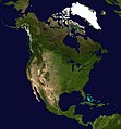 Photo: NASAA composite satellite image of the continent of North America in orthographic projection. North America occupies the northern portion of the landmass generally known as the Americas, with its southern border at the Darién watershed along the Colombia–Panama border. The vast majority of North America rests on the North American Plate, while small parts of California and western Mexico rest on the Pacific Plate; Central America and the Caribbean islands rest on the Caribbean Plate.
 Credit: Martin WaldseemüllerThe Waldseemüller map is a map drawn by German cartographer Martin Waldseemüller originally published in April 1507. It was one of the first maps to chart latitude and longitude precisely, the first map to use the name "America", and the first to depict the Americas as separate from Asia.
 Map: Strebe, using GeocartThe Robinson projection is a map projection of a world map which shows the entire world at once. It was devised by Arthur H. Robinson in 1963 in response to an appeal from the Rand McNally company for a good compromise to the problem of readily showing the whole globe as a flat image. The company has used the projection since that time, and the National Geographic Society used the Robinson from 1988 to 1998.
 Map credit: Robert WilkinsonAn 18th century map of the Iberian Peninsula illustrating various topographic features of the land. The Iberian Peninsula, or Iberia, is located in the extreme southwest of Europe, and includes modern day Spain, Portugal, Gibraltar and Andorra.
 Map: Strebe, using GeocartThe Winkel tripel projection is a modified azimuthal map projection proposed by Oswald Winkel in 1921. The arithmetic mean of the equirectangular projection and the Aitoff projection, it was intended as a compromise between minimizing three kinds of distortion: area, direction and distance.
 Photo credit: NASAAntarctica, the continent surrounding the Earth's South Pole, is the coldest place on earth and is almost entirely covered by ice. Antarctica was discovered in late January 1820. Too cold and dry to support virtually any vascular plants, Antartica's flora presently consists of around 250 lichens, 100 mosses, 25-30 liverworts, and around 700 terrestrial and aquatic algal species.
 Map: Strebe, using GeocartThe Kavrayskiy VII projection is a map projection invented by Vladimir V. Kavrayskiy in 1939 as a general purpose pseudocylindrical projection. It produces maps with low overall distortion, despite its straight, evenly-spaced parallels and a simple formulation.
 Photo: NASAA composite satellite image of the geography of Africa, the Earth's second-largest continent, and its adjacent islands. Separated from Europe by the Mediterranean Sea and from much of Asia by the Red Sea, Africa is joined to Asia at its northeast extremity by the Isthmus of Suez. For geopolitical purposes, the Sinai Peninsula – east of the Suez Canal – is often considered part of Africa, although geographically it belongs in Asia. Africa can be divided into a number of geographic zones: The Atlas Mountains in the north, the Sahara, the coastal plains, and the inner plateaus.
 Map: Strebe, using GeocartThe sinusoidal projection is a pseudocylindrical equal-area map projection. Used as early as the 16th century, this projection shows distances accurately along the central meridian and the equator; areas furthest from these lines are the most distorted.


.jpg)


.svg)

.jpeg)


 Categories
 Commons
 Wikibooks
 Wikidata
 Wikinews
 Wikiquote
 Wikisource
 Wikiversity
 Wikivoyage
 Wiktionary


