
Portal:Scottish islands
The Scottish Islands Portal
Welcome! — Fàilte! — Walcome!
-
-
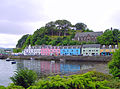
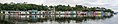
 Portree Waterfront, Isle of Skye
 -
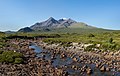
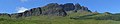
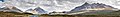 The Cuillin, Isle of Skye
 -

-
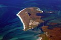
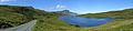
 Seilebost on Harris
 -
 Tombolo connecting St Ninian's Isle to Mainland, Shetland
 -

-
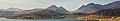
 View from Elgol on the Isle of Skye across to the Cuillin
 -
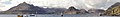
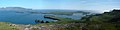
 Looking from the Isle of Mull towards Ardnamurchan peninsula as the Caledonian MacBrayne ferry MV Clansman sails past the Rubha nan Gall lighthouse


Scotland has around 900 offshore islands, most of which are to be found in four main groups: Shetland, Orkney, and the Hebrides, sub-divided into the Inner Hebrides and Outer Hebrides. There are also clusters of islands in the Firth of Clyde, Firth of Forth, and Solway Firth, and numerous small islands within the many bodies of fresh water in Scotland including Loch Lomond and Loch Maree. The largest island is Lewis and Harris which extends to 2,179 square kilometres, and there are a further 200 islands which are greater than 40 hectares in area. Of the remainder, several such as Staffa and the Flannan Isles are well known despite their small size. Some 94 Scottish islands are permanently inhabited, of which 89 are offshore islands. Between 2001 and 2011 Scottish island populations as a whole grew by 4% to 103,702.
The geology and geomorphology of the islands is varied. Some, such as Skye and Mull, are mountainous, while others like Tiree and Sanday are relatively low lying. Many have bedrock made from ancient Archaean Lewisian Gneiss which was formed 3 billion years ago; Shapinsay and other Orkney islands are formed from Old Red Sandstone, which is 400 million years old; and others such as Rùm from more recent Tertiary volcanoes. Many of the islands are swept by strong tides, and the Corryvreckan tide race between Scarba and Jura is one of the largest whirlpools in the world. Other strong tides are to be found in the Pentland Firth between mainland Scotland and Orkney, and another example is the "Grey Dog" between Scarba and Lunga. (More on Scottish islands...)
Selected picture
-

-
-
-

-

-
 Alasdair Crotach MacLeod is the first McLeod not to be buried on Iona; his tomb on Harris dates from 1528, and is among the finest of this period in Scotland
Credit: Gvdwiele
-
 The Corryvreckan Whirlpool in the narrow Gulf of Corryvreckan between Jura and Scarba
Credit: Walter Baxter
-
 Barra Airport is the only one in the world to use a beach as a regular runway
Credit: Steve Houldsworth
-
-
 Eilean Donan Castle at the confluence of three sea lochs, Loch Duich, Loch Long and Loch Alsh
Credit: Diliff
-
-
 The 1st-century Dun Carloway on Lewis is a well-preserved example of an Iron Age broch, a type of complex Atlantic roundhouse only found in Scotland
Credit: Morris R. Maciver
-
 Baile Mòr, the village on Iona
Credit: Clydecoast
-
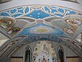 The Italian Chapel on Lamb Holm, Orkney was built from two Nissen huts by Italian prisoners of war during World War 2; the interior frescoes are by Domenico Chiocchetti
Credit: Renata
-
-
 The cliffs of Eshaness, North Mainland, Shetland
Credit: ThoWi
-
 Duart Castle, a 13th-century castle on Mull, the historical seat of Clan Maclean
Credit: Philippe Giabbanelli
-
-
 The tied island of St Ninian's Isle is joined to the Shetland Mainland by the largest tombolo in the UK
Credit: ThoWi
-

-
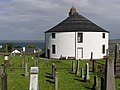 Kilarrow Parish Church, known as the Round Church, is a Georgian building in Bowmore on Islay
Credit: Ronsteenvoorden
-
 White-tailed eagle fishing off Mull, one of several islands to which the birds have been successfully re-introduced
Credit: Jacob Spinks
-
 Blackhouses were the traditional form of house across the Hebrides and the Highlands; this example is at Arnol, Lewis
Credit: LornaMCampbell
-
 Rubha nan Gall lighthouse, Tobermory, Mull, built in 1857 by David and Thomas Stevenson, with a Caledonian MacBrayne ferry in the background
Credit: Colin
-
-
 Neist Point Lighthouse on Skye was designed by David Alan Stevenson and dates from 1909
Credit: Lionel Ulmer
-
 The ferry from Glenelg to Kylerhea on Skye has run for 400 years; the present boat, MV Glenachulish, is the only hand-operated turntable ferry still in operation
Credit: Wojsyl
-

-
-
 Aerial view of the ruins of a hermitage on Canna
Credit: Peter Van den Bossche
-

-
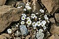 Shetland mouse-ear, a rare plant species unique to Shetland and found only on two serpentine hills in the Keen of Hamar reserve on the island of Unst
Credit: Melvin Grey
-
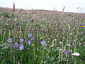 Wildflowers in machair, a coastal dune grassland found in the Outer Hebrides and elsewhere
Credit: Jon Thomson
-
 The Neolithic farmstead of Knap of Howar on Papa Westray, Orkney, dates from 3700 BC and might be the oldest surviving stone dwelling in northern Europe
Credit: Me677
-
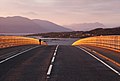 Skye Bridge, opened in 1995; the toll was lifted in 2004
Credit: Gene Selkov
-

-
 The Bruichladdich distillery, one of eight on Islay; single-malt whisky is a major product of the islands
Credit: Bdcl1881


.jpg)


.jpg)
.jpg)

.jpg)


.jpg)


_2.jpg)


Selected island group

The Islands of the Forth are a group of small islands located in the Firth of Forth and in the estuary of the River Forth on the east coast of Scotland. Most of the group lie in the open waters of the firth, between the Lothians and Fife, with the majority to the east of the city of Edinburgh. Two islands lie further west in the river estuary.
The islands have a varied geology and history; over the centuries, several have had both ecclesiastical connections and a history of involvement in military occupations. Various lighthouses and other aids to navigation have been erected on the islands and skerries — one of these dates to the 17th century. But only one of the islands still has year-round human inhabitants. The area has diverse bird and sea life. The scientific name for the northern gannet was chosen in recognition of this bird's connection with the Bass Rock.
There are only a few islands off the coast of eastern Scotland, and most of them of any significant size are included in this group. (Full article...)
News

- 12 February: The BiFab construction yard at Arnish near Stornoway, Isle of Lewis, is purchased by InfraStrata.
- 11 February: Wild fires occur in Benbecula; and at Achmore and Sildinish in the Isle of Lewis; Horsaclete in Harris; Brevig in Barra; and Eubhal in North Uist.
- 19 January: Barra and Vatersay are put under tier-4 restrictions after an outbreak of Covid-19.
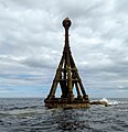
- 18 January: The Shetland Space Centre submits plans for a spaceport on Unst (proposed site pictured), Shetland, including three rocket launch pads.
- 8 January: Distilleries in Orkney and South Uist receive government grants to research ways of reducing their CO2 emissions.
- 4 January: After the UK leaves the European Union, the Northern Celt, an Irish fishing boat based out of Greencastle, County Donegal, is ordered to leave the 12-nautical-mile zone around Rockall by officers of Marine Scotland.
- 1 January: A total of 72 cases of Covid-19 are recorded in an ongoing outbreak in Shetland.
- 9 December: A review by a committee of MSPs into the commissioning and building of two new dual-fuel Caledonian MacBrayne ferries, MV Glen Sannox and "hull 802", criticises CMAL, Transport Scotland and the Scottish government, as well as the ship builders, Ferguson Marine.
- 3 December: North-east Lewis, Sea of the Hebrides and Shiant East Bank are designated Marine Protected Areas, while East Mainland Coast Shetland, Sound of Gigha, Coll and Tiree, Rùm, the west coast of the Outer Hebrides, and the waters off St Kilda and Foula are designated Special Protection Areas.
- 30 November: Michael Russell, MSP for Argyll and Bute, and David Stewart and John Finnie, MSPs for the Highlands and Islands region, will stand down at the 2021 election.
- 17 November: Phytophthora ramorum-infected larch trees in Arran are to be felled over a 543-acre area, to prevent the fungus-like pathogen from spreading.
- 4 November: The Scottish Wildlife Trust objects to a proposed salmon farm in the Marine Protected Area of Wester Ross, near Horse Island, Summer Isles, because of the potential impact on kelp forests and maerl beds.
Selected fauna

The Highland (Scottish Gaelic: Bò Ghàidhealach; Scots: Heilan coo) is a Scottish breed of rustic cattle. It originated in the Scottish Highlands and the Western Islands of Scotland and has long horns and a long shaggy coat. It is a hardy breed, able to withstand the intemperate conditions in the region. The first herd-book dates from 1885; two types – a smaller island type, usually black, and a larger mainland type, usually dun – were registered as a single breed. It is reared primarily for beef, and has been exported to several other countries. (Full article...)
Selected history & culture article
Prehistoric Orkney refers only to the prehistory of the Orkney archipelago of Scotland that begins with human occupation. (The islands’ history before human occupation is part of the geology of Scotland.) Although some records referring to Orkney survive that were written during the Roman invasions of Scotland, “prehistory” in northern Scotland is defined as lasting until the start of Scotland's Early Historic Period (around AD 600).
There are numerous important prehistoric remains in Orkney, especially from the Neolithic period. Four of these remains today constitute a World Heritage Site. There are diverse reasons for the abundance of the archaeological record. The sandstone bedrock provides easily workable stone materials and the wind-blown sands have helped preserve several sites. The relative lack of industrialisation and the low incidence of ploughing have also helped to preserve these ancient monuments. In addition, local tradition hints at both fear and veneration of these ancient structures (perhaps inherited from the Norse period of occupation), and these attitudes may have helped prevent human interference with their structural integrity.
Prehistory is conventionally divided into a number of shorter periods, but differentiating these various eras of human history is a complex task – their boundaries are uncertain, and the changes between them are gradual. A number of the sites span long periods of time, and, in particular, the distinctions between the Neolithic and the later periods are not clear cut. However, in general, the Paleolithic lasted until the retreat of the ice, the Mesolithic until the adoption of farming and the Neolithic until metalworking commenced The Neolithic period's extraordinary wealth of structures is not matched by the remains from earlier periods, in which the evidence of human occupation is sparse or non-existent - nor is it matched by remains from the later Bronze Age, which provides a relative dearth of evidence. However, the subsequent Iron Age supported a return to monumental building projects, especially brochs.
Formal excavations were first recorded in the late 18th century. Over time, investigators’ understanding of the structures they uncovered progressed—from little more than folklore in the beginning, to modern archaeological science today. (Full article...)
Selected island

The Isle of Skye, or simply Skye (/skaɪ/; Scottish Gaelic: An t-Eilean Sgitheanach or Eilean a' Cheò), is the largest and northernmost of the major islands in the Inner Hebrides of Scotland. The island's peninsulas radiate from a mountainous hub dominated by the Cuillin, the rocky slopes of which provide some of the most dramatic mountain scenery in the country. Although Sgitheanach has been suggested to describe a winged shape, no definitive agreement exists as to the name's origins.
The island has been occupied since the Mesolithic period, and over its history has been occupied at various times by Celtic tribes including the Picts and the Gaels, Scandinavian Vikings, and most notably the powerful integrated Norse-Gaels clans of MacLeod and MacDonald. The island was considered to be under Norwegian suzerainty until the 1266 Treaty of Perth, which transferred control over to Scotland.
The 18th-century Jacobite risings led to the breaking-up of the clan system and later clearances that replaced entire communities with sheep farms, some of which involved forced emigrations to distant lands. Resident numbers declined from over 20,000 in the early 19th century to just under 9,000 by the closing decade of the 20th century. Skye's population increased by 4% between 1991 and 2001. About a third of the residents were Gaelic speakers in 2001, and although their numbers are in decline, this aspect of island culture remains important.
The main industries are tourism, agriculture, fishing, and forestry. Skye is part of the Highland Council local government area and wholly within the historic county of Inverness-shire. The island's largest settlement is Portree, which is also its capital, known for its picturesque harbour. Links to various nearby islands by ferry are available, and since 1995, to the mainland by a road bridge. The climate is mild, wet, and windy. The abundant wildlife includes the golden eagle, red deer, and Atlantic salmon. The local flora is dominated by heather moor, and nationally important invertebrate populations live on the surrounding sea bed. Skye has provided the locations for various novels and feature films and is celebrated in poetry and song. (Full article...)
Did you know?

- ... that an Edinburgh judge and Member of Parliament had his wife, Lady Grange (burial site pictured) kidnapped and effectively imprisoned for thirteen years in various remote parts of western Scotland?
- ... that the German battleship SMS Grosser Kurfürst was involved in a series of accidents during her service career, including collisions and several groundings?
- ...that King Rögnvaldr Óláfsson was assassinated by a knight named Ívarr and his accomplices?
- ... that Mugeary, which is 25 miles from Glenelg in Scotland, is the namesake of a rock found millions of miles away but just a few hundred feet from Glenelg?
Selected portrait
-
-
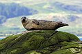
 Seals hauled out by Lyrie Geo on Hoy
Credit: Claire Pegrum
-
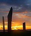 The Standing Stones of Stenness, near Stromness, Orkney, started by 3100 BC and possibly Britain's oldest henge site
Credit: Fantoman400
-
 Columba was a 6th-century Irish-born saint who spread Christianity in Scotland and founded Iona Abbey, where he is commemorated in this stained-glass window
Credit: Vegansoldier
-

-
 The 8th-century Kildalton Cross, Islay, one of the best-preserved Celtic crosses in Scotland
Credit: Tom Richardson
-
-
 Scottish Gaelic speakers in the 2011 census; the Outer Hebrides, Tiree, Raasay, Skye and Lismore have the highest proportion of speakers
Credit: SkateTier
-

-
-

-
 The North Carr Beacon at low tide; the unlit beacon was built between 1813 and 1821 by Robert Stevenson to warn shipping of the North Carr Reef near Fife Ness
Credit: Kathrinpassig
-
 Puffins and guillemots on Lunga in the Treshnish Isles, with Bac Mòr (known as Dutchman's Cap for its distinctive shape) in the background
Credit: Simaron


Selected geography article

Threave Castle is situated on an island in the River Dee, 2.5 kilometres (1.6 mi) west of Castle Douglas in the historical county of Kirkcudbrightshire in the Dumfries and Galloway region of Scotland.
Built in the 1370s by Archibald the Grim, it was a stronghold of the "Black Douglases", Earls of Douglas and Lords of Galloway, until their fall in 1455. For part of this time, the castle and the lordship of Galloway were controlled by Princess Margaret, daughter of King Robert III and widow of the 4th Earl. In 1449 Threave was regained by the 8th earl, Scotland's most powerful magnate, who controlled extensive lands and numerous castles. He fortified Threave with an "artillery house", a sophisticated defence for its time. The excessive power of the Black Douglas lords led to their overthrow by King James II in 1455, after which Threave was besieged and captured by the King's men.
It became a royal castle, and in the 16th century hereditary responsibility for Threave was given to the Lords Maxwell. It was briefly held by the English in the 1540s, but did not see serious action until the Bishops' Wars, when in 1640 a royalist garrison was besieged by a force of Covenanters. Partially dismantled, the castle remained largely unused until given into state care in 1913. The ruins, comprising the substantially complete tower house and the L-shaped artillery house, are today maintained by Historic Environment Scotland as a scheduled monument.
The castle complex is open to the public. (Full article...)
Selected biography

Magnus III Olafsson (Old Norse: Magnús Óláfsson, Norwegian: Magnus Olavsson; 1073 – 24 August 1103), better known as Magnus Barefoot (Old Norse: Magnús berfœttr, Norwegian: Magnus Berrføtt), was the King of Norway from 1093 until his death in 1103. His reign was marked by aggressive military campaigns and conquest, particularly in the Norse-dominated parts of the British Isles, where he extended his rule to the Kingdom of the Isles and Dublin.
As the only son of King Olaf Kyrre, Magnus was proclaimed king in southeastern Norway shortly after his father's death in 1093. In the north his claim was contested by his cousin, Haakon Magnusson (son of King Magnus Haraldsson), and the two co-ruled uneasily until Haakon's death in 1095. Disgruntled members of the nobility refused to recognise Magnus after his cousin's death, but the insurrection was short-lived. After securing his position domestically, Magnus campaigned around the Irish Sea from 1098 to 1099. He raided through Orkney, the Hebrides and Mann (the Northern and Southern Isles), and ensured Norwegian control by a treaty with the Scottish king. Based on Mann during his time in the west, Magnus had a number of forts and houses built on the island and probably also obtained suzerainty of Galloway. He sailed to Wales later in his expedition, gaining the support of Anglesey (and the Gwynedd) after aiding against the invading Norman forces from the island.
Following his return to Norway, Magnus led campaigns into Dalsland and Västergötland in Sweden, claiming an ancient border with the country. After two unsuccessful invasions and a number of skirmishes Danish king Eric Evergood initiated peace talks among the three Scandinavian monarchs, fearing that the conflict would get out of hand. Magnus concluded peace with the Swedes in 1101 by agreeing to marry Margaret, daughter of the Swedish king Inge Stenkilsson. In return, Magnus gained Dalsland as part of her dowry. He set out on his final western campaign in 1102, and may have sought to conquer Ireland. Magnus entered into an alliance with Irish king Muirchertach Ua Briain of Munster, who recognised Magnus's control of Dublin. Under unclear circumstances, while obtaining food supplies for his return to Norway, Magnus was killed in an ambush by the Ulaid the next year; territorial advances characterising his reign ended with his death.
Into modern times, his legacy has remained more pronounced in Ireland and Scotland than in his native Norway. Among the few domestic developments known during his reign, Norway developed a more centralised rule and moved closer to the European model of church organisation. Popularly portrayed as a Viking warrior rather than a medieval monarch, Magnus was the last Norwegian king to fall in battle abroad, and he may in some respects be considered the final Viking king. (Full article...)
Related portals
Selected panorama
-

-
-

-
-

-
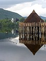
 Iona Abbey
Credit: Oliver-Bonjoch
-

-
-
-

-
 Small freshwater islets on Loch Assynt
Credit: Vincent
-
 Eilean Donan
Credit: Stefan Krause

Topics
|  | ||||||||||||||||
|
| |||||||||||||||||
| |||||||||||||||||
| |||||||||||||||||
| |||||||||||||||||
| |||||||||||||||||
| |||||||||||||||||
| |||||||||||||||||
Categories
The main category is Islands of Scotland, with subcategories

Things you can do
- Add new articles to the project by placing {{WPSI|class=|importance=}} on the talk page
- Add a link to the portal in the "See also" section of relevant articles with {{Portal|Scottish islands}}
- Take requested photographs or create requested pages, including Prehistoric Hebrides, Trialabreac, Dog Isle...
- Expand a Scottish Islands stub into a full article, adding images, citations, references and infoboxes; did you know that if you expand one 5x, you can nominate it for Did You Know?
- Improve one of the highest priority articles, including Mull, Bute, North & South Uist, Columba, Highland Clearances, Sorley MacLean, St Magnus Cathedral...
- Follow these hints to improve a B-class article and nominate it for Good Article

- Suggest articles, pictures, interesting facts, events and news to be featured here on the portal
Wikiproject

Associated Wikimedia
The following Wikimedia Foundation sister projects provide more on this subject:
-
 Commons
Free media repository -
 Wikibooks
Free textbooks and manuals -
 Wikidata
Free knowledge base -
 Wikinews
Free-content news -
 Wikiquote
Collection of quotations -
 Wikisource
Free-content library -
 Wikiversity
Free learning tools -
 Wikivoyage
Free travel guide -
 Wiktionary
Dictionary and thesaurus


