
Portal:World
The World Portal


The world is the totality of entities, the whole of reality, or everything that exists. The nature of the world has been conceptualized differently in different fields. Some conceptions see the world as unique while others talk of a "plurality of worlds". Some treat the world as one simple object while others analyze the world as a complex made up of parts.
In scientific cosmology, the world or universe is commonly defined as "[t]he totality of all space and time; all that is, has been, and will be". Theories of modality talk of possible worlds as complete and consistent ways how things could have been. Phenomenology, starting from the horizon of co-given objects present in the periphery of every experience, defines the world as the biggest horizon or the "horizon of all horizons". In philosophy of mind, the world is contrasted with the mind as that which is represented by the mind. Theology conceptualizes the world in relation to God, for example, as God's creation, as identical to God or as the two being interdependent. In religions, there is a tendency to downgrade the material or sensory world in favor of a spiritual world to be sought through religious practice. A comprehensive representation of the world and our place in it, as is found in religions, is known as a worldview. Cosmogony is the field that studies the origin or creation of the world while eschatology refers to the science or doctrine of the last things or of the end of the world.
In various contexts, the term "world" takes a more restricted meaning associated, for example, with the Earth and all life on it, with humanity as a whole or with an international or intercontinental scope. In this sense, world history refers to the history of humanity as a whole and world politics is the discipline of political science studying issues that transcend nations and continents. Other examples include terms such as "world religion", "world language", "world government", "world war", "world population", "world economy", or "world championship". (Full article...)
Selected articles -
-


Leibniz representation of universe resulting by combination of Aristotle four elements
The classical elements typically refer to earth, water, air, fire, and (later) aether which were proposed to explain the nature and complexity of all matter in terms of simpler substances. Ancient cultures in Greece, Angola, Tibet, India, and Mali had similar lists which sometimes referred, in local languages, to "air" as "wind" and the fifth element as "void".
These different cultures and even individual philosophers had widely varying explanations concerning their attributes and how they related to observable phenomena as well as cosmology. Sometimes these theories overlapped with mythology and were personified in deities. Some of these interpretations included atomism (the idea of very small, indivisible portions of matter), but other interpretations considered the elements to be divisible into infinitely small pieces without changing their nature. (Full article...) -
 Least developed countries (designated by the UN as of 2023)Former least developed countries
The least developed countries (LDCs) are developing countries listed by the United Nations that exhibit the lowest indicators of socioeconomic development. The concept of LDCs originated in the late 1960s and the first group of LDCs was listed by the UN in its resolution 2768 (XXVI) on 18 November 1971.
A country is classified among the Least Developed Countries if it meets three criteria:- Poverty – adjustable criterion based on Gross national income (GNI) per capita averaged over three years. As of 2018[update], a country must have GNI per capita less than US$1,025 to be included on the list, and over $1,230 to graduate from it.
- Human resource weakness (based on indicators of nutrition, health, education and adult literacy).
- Economic vulnerability (based on instability of agricultural production, instability of exports of goods and services, economic importance of non-traditional activities, merchandise export concentration, handicap of economic smallness, and the percentage of population displaced by natural disasters).
-
The Global Climate Observing System (GCOS) was established in 1992 as an outcome of the Second World Climate Conference, to ensure that the observations and information needed to address climate-related issues are obtained and made available to all potential users. The GCOS is co-sponsored by the World Meteorological Organization (WMO), the Intergovernmental Oceanographic Commission (IOC) of UNESCO, the United Nations Environment Programme (UNEP), and the International Council for Science (ICSU). In order to assess and monitor the adequacy of in-situ observation networks as well as satellite-based observing systems, GCOS regularly reports on the adequacy of the current climate observing system to the United Nations Framework Convention on Climate Change (UNFCCC), and thereby identifies the needs of the current climate observing system.
GCOS is a system that comprises the climate-relevant components of many contributing observing systems and networks. Its mission is to help ensure that these contributing systems, taken as a whole, provide the comprehensive information on the global climate system that is required by users, including individuals, national and international organizations, institutions and agencies. The programme promotes the sustained provision and availability of reliable physical, chemical and biological observations and data records for the total climate system - across the atmospheric, oceanic and terrestrial domains, including the hydrological cycle, the carbon cycle and the cryosphere. (Full article...) -

The United Nations Framework Convention on Climate Change (UNFCCC) is the UN process for negotiating an agreement to limit dangerous climate change. It is an international treaty among countries to combat "dangerous human interference with the climate system". The main way to do this is limiting the increase in greenhouse gases in the atmosphere. It was signed in 1992 by 154 states at the United Nations Conference on Environment and Development (UNCED), informally known as the Earth Summit, held in Rio de Janeiro. The treaty entered into force on 21 March 1994. "UNFCCC" is also the name of the Secretariat charged with supporting the operation of the convention, with offices on the UN Campus in Bonn, Germany.
The convention's main objective is explained in Article 2. It is the "stabilization of greenhouse gas concentrations in the atmosphere at a level that would prevent dangerous anthropogenic [i.e., human-caused] interference with the climate system". The treaty calls for continuing scientific research into the climate. This sresearchspuports meetings and negotiations to lead to agreements. The aim is to allow ecosystems to adapt to climate change. At the same time it aims to ensure there are no threats to food production from climate change or measures to address it. And it aims to enable economic development to proceed in a sustainable manner. (Full article...) -

Miss Universe is an annual international major beauty pageant that is run by a United States and Thailand-based Miss Universe Organization. Along with Miss World, Miss International, and Miss Earth, it is one of the Big Four beauty pageants.
The Miss Universe Organization and its brand, along with its sister pageants, Miss USA and Miss Teen USA, is currently owned by JKN Global Group and Legacy Holding Group USA Inc., an American division of Mexican company Legacy Holding through the joint venture company JKN Legacy Inc. Telemundo has the licensing rights to air the pageant through 2023. The pageant's advocacy is "humanitarian issues and is a voice to affect positive change in the world." (Full article...) -
Superpower describes a state or supranational union that holds a dominant position characterized by the ability to exert influence or project power on a global scale. This is done through the combined means of economic, military, technological, political, and cultural strength as well as diplomatic and soft power influence. Traditionally, superpowers are preeminent among the great powers. While a great power state is capable of exerting its influence globally, superpowers are states so influential that no significant action can be taken by the global community without first considering the positions of the superpowers on the issue.
In 1944, during World War II, the term was first applied to the United States, the British Empire, and the Soviet Union. During the Cold War, the British Empire dissolved, leaving the United States and the Soviet Union to dominate world affairs. At the end of the Cold War and the dissolution of the Soviet Union in 1991, the United States became, and remains, the world's sole superpower, a position sometimes referred to as that of a "hyperpower". Since the late 2010s and into the 2020s, China has been described as a new superpower, as China poses "the most significant challenge of any nation-state in the world to the United States". (Full article...) -
The World Factbook, also known as the CIA World Factbook, is a reference resource produced by the Central Intelligence Agency (CIA) with almanac-style information about the countries of the world. The official print version is available from the Government Publishing Office. The Factbook is available in the form of a website that is partially updated every week. It is also available for download for use off-line. It provides a two- to three-page summary of the demographics, geography, communications, government, economy, and military of 266 international entities, including U.S.-recognized countries, dependencies, and other areas in the world.
The World Factbook is prepared by the CIA for the use of U.S. government officials, and its style, format, coverage, and content are primarily designed to meet their requirements. It is also frequently used as a resource for academic research papers and news articles. As a work of the U.S. government, it is in the public domain in the United States. (Full article...)


General images -
-
 Earth's night-side upper atmosphere appearing from the bottom as bands of afterglow illuminating the troposphere in orange with silhouettes of clouds, and the stratosphere in white and blue. Next the mesosphere (pink area) extends to the orange and faintly green line of the lowest airglow, at about one hundred kilometers at the edge of space and the lower edge of the thermosphere (invisible). Continuing with green and red bands of aurorae stretching over several hundred kilometers. (from Earth)
 -

-
 An animation of the changing density of productive vegetation on land (low in brown; heavy in dark green) and phytoplankton at the ocean surface (low in purple; high in yellow) (from Earth)
 -

-

-
 Persepolis, Achaemenid Empire, 6th century BCE
 -
 Dinosaurs were the dominant terrestrial vertebrates throughout most of the Mesozoic (from History of Earth)
 -

-

-
 Standing Buddha from Gandhara, 2nd century CE
 -
 View of Earth from the Moon by the Lunar Reconnaissance Orbiter (from Earth)
 -
 Battle during 1281 Mongol invasion of Japan
 -
 A composite image of Earth, with its different types of surface discernible: Earth's surface dominating Ocean (blue), Africa with lush (green) to dry (brown) land and Earth's polar ice in the form of Antarctic sea ice (grey) covering the Antarctic or Southern Ocean and the Antarctic ice sheet (white) covering Antarctica. (from Earth)
 -
 Artist's impression of the enormous collision that probably formed the Moon (from History of Earth)
 -

-

-

-
 Trilobites first appeared during the Cambrian period and were among the most widespread and diverse groups of Paleozoic organisms. (from History of Earth)
 -
 A view of Earth with different layers of its atmosphere visible: the troposphere with its clouds casting shadows, a band of stratospheric blue sky at the horizon, and a line of green airglow of the lower thermosphere around an altitude of 100 km, at the edge of space (from Earth)
 -
 Ajloun Castle, Jordan
 -
 Angkor Wat temple complex, Cambodia, early 12th century
 -
 A composite image of artificial light emissions at night on a map of Earth (from Earth)
 -
 Geologic map of North America, color-coded by age. From most recent to oldest, age is indicated by yellow, green, blue, and red. The reds and pinks indicate rock from the Archean.
 -
 The replicator in virtually all known life is deoxyribonucleic acid. DNA is far more complex than the original replicator and its replication systems are highly elaborate. (from History of Earth)
 -
 Pangaea was a supercontinent that existed from about 300 to 180 Ma. The outlines of the modern continents and other landmasses are indicated on this map. (from History of Earth)
 -
 Fall of the Berlin Wall, 1989
 -
 The Pantheon, originally a Roman temple, now a Catholic church
 -

-
 An artist's impression of the Archean, the eon after Earth's formation, featuring round stromatolites, which are early oxygen-producing forms of life from billions of years ago. After the Late Heavy Bombardment, Earth's crust had cooled, its water-rich barren surface is marked by continents and volcanoes, with the Moon still orbiting Earth half as far as it is today, appearing 2.8 times larger and producing strong tides. (from Earth)
 -
 Earth's axial tilt causing different angles of seasonal illumination at different orbital positions around the Sun (from Earth)
 -
 Lithified stromatolites on the shores of Lake Thetis, Western Australia. Archean stromatolites are the first direct fossil traces of life on Earth. (from History of Earth)
 -
 A pillar at Göbekli Tepe
 -
 Taj Mahal, Mughal Empire, India
 -
 Graph showing range of estimated partial pressure of atmospheric oxygen through geologic time (from History of Earth)
 -

-
 Last Moon landing: Apollo 17 (1972)
 -
 Artist's impression of a Hadean landscape with the relatively newly formed Moon still looming closely over Earth and both bodies sustaining strong volcanism. (from History of Earth)
 -
 Image of the physical world, captured by the Hubble Space Telescope (from World)
 -
 An artist's rendering of a protoplanetary disk (from History of Earth)
 -
Artist's impression of Earth during the later Archean, the largely cooled planetary crust and water-rich barren surface, marked by volcanoes and continents, features already round microbialites. The Moon, still orbiting Earth much closer than today and still dominating Earth's sky, produced strong tides. (from History of Earth)
-
 Notre-Dame de Paris, France
 -
 Earth's western hemisphere showing topography relative to Earth's center instead of to mean sea level, as in common topographic maps (from Earth)
 -
 Japanese depiction of a Portuguese carrack. European maritime innovations led to proto-globalization.
 -
 Change in average surface air temperature and drivers for that change. Human activity has caused increased temperatures, with natural forces adding some variability. (from Earth)
 -
 An artist's impression of ice age Earth at glacial maximum. (from History of Earth)
 -
 A Benin Bronze head from Nigeria
 -
 Earth's history with time-spans of the eons to scale (from History of Earth)
 -
 First airplane, the Wright Flyer, flew on 17 December 1903.
 -

-
 The pale orange dot, an artist's impression of the early Earth which might have appeared orange through its hazy methane rich prebiotic second atmosphere. Earth's atmosphere at this stage was somewhat comparable to today's atmosphere of Titan. (from History of Earth)
 -

-
 A schematic view of Earth's magnetosphere with solar wind flowing from left to right (from Earth)
 -

-
 Tiktaalik, a fish with limb-like fins and a predecessor of tetrapods. Reconstruction from fossils about 375 million years old. (from History of Earth)
 -
 Artist's conception of Hadean Eon Earth, when it was much hotter and inhospitable to all forms of life. (from History of Earth)
 -
 Yggdrasil, an attempt to reconstruct the Norse world tree which connects the heavens, the world, and the underworld. (from World)
 -
 Florence, birthplace of the Italian Renaissance
 -
 A 2012 artistic impression of the early Solar System's protoplanetary disk from which Earth and other Solar System bodies were formed (from Earth)
 -
 A map of heat flow from Earth's interior to the surface of Earth's crust, mostly along the oceanic ridges (from Earth)
 -
 Great Mosque of Kairouan, Tunisia, founded 670 CE
 -
 Vitruvian Man by Leonardo da Vinci epitomizes the advances in art and science seen during the Renaissance. (from History of Earth)
 -
 Artist's rendition of an oxinated fully-frozen Snowball Earth with no remaining liquid surface water. (from History of Earth)
 -
 Artist's conception of Devonian flora (from History of Earth)
 -
 Great Pyramids of Giza, Egypt
 -

-

-
 Chennakesava Temple, Belur, India
 -
 Chloroplasts in the cells of a moss (from History of Earth)
 -
 Earth's land use for human agriculture in 2019 (from Earth)
 -
 Empires of the world in 1898
 -

-

-
 Obelisk of Axum, Ethiopia
 -
 Shanghai. China urbanized rapidly in the 21st century.
 -
 Ming dynasty section, Great Wall of China
 -
 Machu Picchu, Inca Empire, Peru
 -
 A computer-generated image mapping the prevalence of artificial satellites and space debris around Earth in geosynchronous and low Earth orbit (from Earth)
 -
 A view of Earth with its global ocean and cloud cover, which dominate Earth's surface and hydrosphere; at Earth's polar regions, its hydrosphere forms larger areas of ice cover. (from Earth)
 -

-
 Cross-section through a liposome (from History of Earth)
 -
 A banded iron formation from the 3.15 Ga Moodies Group, Barberton Greenstone Belt, South Africa. Red layers represent the times when oxygen was available; gray layers were formed in anoxic circumstances. (from History of Earth)
 -
 Tracy Caldwell Dyson, a NASA astronaut, observing Earth from the Cupola module at the International Space Station on 11 September 2010 (from Earth)
 -

-

-
 A 580 million year old fossil of Spriggina floundensi, an animal from the Ediacaran period. Such life forms could have been ancestors to the many new forms that originated in the Cambrian Explosion. (from History of Earth)
 -
 A reconstruction of human history based on fossil data. (from History of Earth)
 -
 Satellite time lapse imagery of Earth's rotation showing axis tilt (from Earth)
 -
 Olmec colossal head, now at the Museo de Antropología de Xalapa
 -
 "Lucy", the first Australopithecus afarensis skeleton found. Lucy was only 1.06 m (3 ft 6 in) tall.
 -
 A reconstruction of Pannotia (550 Ma). (from History of Earth)
 -
 Map of peopling of the world (Southern Dispersal paradigm), in thousands of years ago.
 -
Pale orange dot, an artist's impression of Early Earth, featuring its tinted orange methane-rich early atmosphere (from Earth)


.jpeg)


.jpg)


.jpg)


.jpg)


.svg)


Megacities of the world -

Kolkata, also known as Calcutta (its official name until 2001), is the capital and largest city of the Indian state of West Bengal. It lies on the eastern bank of the Hooghly River, 80 km (50 mi) west of the border with Bangladesh. It is the primary financial and commercial centre of eastern and northeastern India. Kolkata is the seventh most populous city of India with an estimated city proper population of 4.5 million (0.45 crore). It is the centre of the Kolkata Metropolitan Region, one of the most populous metropolitan areas in the world with a population of over 15 million (1.5 crore) residents. Kolkata is the de facto cultural capital of India and a historically and culturally significant city in the historic region of Bengal. It is the second largest Bengali-speaking city in the world. It has the highest number of Nobel laureates among all cities in India.
The three villages that predated Calcutta were ruled by the Nawab of Bengal under Mughal suzerainty. After the Nawab granted the East India Company a trading licence in 1690, the area was developed by the Company into Fort William. Nawab Siraj ud-Daulah occupied the fort in 1756 but was defeated at the Battle of Plassey in 1757, after his general Mir Jafar mutinied in support of the company, and was later made the Nawab for a brief time. Under company and later crown rule, Calcutta served as the de facto capital of India until 1911. Calcutta was the second largest city in the British Empire, after London, and was the centre of bureaucracy, politics, law, education, science and the arts in India. The city was associated with many of the figures and movements of the Bengali Renaissance. It was the hotbed of the Indian nationalist movement. The University of Calcutta, first modern university in south Asia and its affiliated colleges produced many leading figures of South Asia. (Full article...)Did you know -

- ... that St. Bernward in Döhren was consecrated in 1893, when part of Christoph Hehl's design of a basilica in the Romanesque Revival style was built, but the building was only completed after World War II?
- ... that the use of the flag of Gdańsk was discontinued during World War II and was not restored until 1991?
- ... that the American Schools at War program raised over $2 billion (over $28 billion today) to help pay for World War II?
- ... that in developing the Dictionary of Women Worldwide, editors Anne Commire and Deborah Klezmer found other biographical dictionaries often devoted only five percent of their text to women?
- ... that the first prayer of "Hilf, Herr meines Lebens", a Christian song written when its author was age 85, is not to be on earth in vain?
- ... that touch-screen technology, pay-at-the-pump, car phones, and Coca-Cola Cherry were shown at the 1982 World's Fair?
- ... that the Bancroft region is the only place in Canada and one of very few places in the world where uranium has been mined from pegmatite rock?
- ... that more than a decade after Edgar Wright assembled the cast of Scott Pilgrim vs. the World, he helped to convince them all to reprise their roles in an anime adaptation of the source material?
Countries of the world -

The Republic of the Congo, also known as Congo-Brazzaville, West Congo, Congo Republic, ROC, or simply either Congo or the Congo, is a country located on the western coast of Central Africa to the west of the Congo River. It is bordered to the west by Gabon, to the northwest by Cameroon, to the northeast by the Central African Republic, to the southeast by the Democratic Republic of the Congo, to the south by the Angolan exclave of Cabinda, and to the southwest by the Atlantic Ocean.
The region was dominated by Bantu-speaking tribes at least 3,000 years ago, who built trade links leading into the Congo River basin. Congo was formerly part of the French colony of Equatorial Africa. The Republic of the Congo was established on 28 November 1958 and gained independence from France in 1960. It was a Marxist–Leninist state from 1969 to 1992, under the name People's Republic of the Congo. The country has had multi-party elections since 1992, but a democratically elected government was ousted in the 1997 Republic of the Congo Civil War. President Denis Sassou Nguesso, who first came to power in 1979, ruled until 1992 and then again since after his reinstatement. (Full article...)Related portals
Protected areas of the world -
-
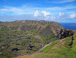
Rano Kau, Parque National Rapa Nui, Easter Island
The protected areas of Chile are areas that have natural beauty or significant historical value protected by the government of Chile. These protected areas cover over 140,000 km2 (54,054 sq mi), which is 19% of the territory of Chile. The National System of Protected Wild Areas (SNASPE by its Spanish acronym) is regulated by law #18,362 passed in 1984, and administered by the National Forest Corporation (CONAF).
There are three types of territories: (Full article...) -

Viru bog in Lahemaa National Park
Protected areas in Estonia are national parks, nature reserves and landscape protection areas (nature parks).
Estonia has five national parks, 167 nature reserves and 152 landscape conservation areas. In addition, there are 116 (118) protected areas with an old (Soviet-era) protection regulation and 537 parks. In total, 18.1% of Estonia are protected nature areas, with Lääne County having the highest percentage (32%) and Põlva County the lowest percentage of protected areas, about 9%. (Full article...) -

Overview of IUCN Protected area - WAP (W, Arli, Pendjari) area - Niger, Burkina Faso, and Benin
The following is a list of protected areas of Burkina Faso. (Full article...) -

Flamingos at the Ras Al Khor Wildlife Sanctuary
This is a list of protected areas of United Arab Emirates:- Abu Dhabi Mangrove and Coastal Wetland Reserve
- Ain al Faydah National Park
- Al Awir Nature Reserve
- Al Khawanij Nature Reserve
- Al Maha Nature Reserve
- Al Marmoom Desert Conservation Reserve
- Al Wohoosh Desert Conservation Reserve
- Dubai Desert Conservation Reserve National Park
- Hatta Nature Reserve
- Jabal Ali Wildlife Sanctuary
- Khor Kalba Nature Reserve
- Marawah Marine Protected Area
- Mushrif National Park
- Nadd Al Sheba Nature Reserve
- Rams Lagoon Reserve
- Ras Al Khor Wildlife Sanctuary
- Wadi Wurayah National Park
- Zirkuh Island Bird Sanctuary
-
Protected areas of West Bengal cover 4% of the state area. Forests make up 14% of the geographical area of West Bengal, which is lower than the national average of 33%. West Bengal has a wide variety of fauna, including Bengal tigers, Indian leopards, sloth and Himalayan black bears, chital and sambar (deer), Indian boars, pygmy hogs, Indian elephants, Indian peafowl, great Indian hornbills, Eurasian spoonbills, brahminy ducks, king and Indian cobras, white-lipped pit viper, Indian and reticulated pythons, mugger crocodiles, saltwater crocodiles, gharials, and many more. A huge montane forest, Dooars, is situated in the Northern West Bengal districts of Alipur Duar, Darjeeling, and Kalimpong. Part of the world's largest mangrove forest, Sundarbans, is located in southern West Bengal.
There are 6 national parks and 15 wildlife sanctuaries in West Bengal. (Full article...) -
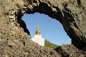
"Temple Gate" Rock formation at Alkhanay National Park
Protected areas of Russia, (official Russian title: Russian: Особо охраняемые природные территории, literally "Specially Protected Natural Areas"), is governed by the corresponding 1995 law of the Russian Federation. (Full article...) -

A view at Kintrishi National Park
The South Caucasian nation of Georgia is home to several protected areas, which receive protection because of their environmental, cultural or similar value. The oldest of these – now known as the Lagodekhi Protected Areas – dates back to 1912, when Georgia was part of the Russian Empire.
The total area of Georgia's protected terrestrial territories is 6,501 km2 (2,510 sq mi), which amounts to approximately 9.29% of the country's territory. In addition 153 km2 (59 sq mi) of marine area protected, or 0.67% of the country's territorial waters. There are a total of 89 protected areas, including 14 Strict Nature Reserves, 12 National Parks, 20 Managed Nature Reserves, 40 Natural Monuments, 2 Ramsar sites and 1 Protected Landscape. Strict nature reserves comprise 140,672 ha, while national parks cover 276,724 ha. The total number of visitors to Georgia's protected areas was just under 1.2 million in 2019. (Full article...) -
Forests in the state of Himachal Pradesh (northern India) currently cover an area of nearly 37,939 square kilometres (14,648 sq mi), which is about 68.16% of the total land area of the state. The forests were once considered to be the main source of income of the state and most of the original forests were clear felled. The emphasis has shifted, however, from exploitation to conservation. The state government aims to increase forest cover to 50% of the total land area. There have been various projects, including the establishment of protected areas such as National Parks, designed to preserve and expand the forests. (Full article...)
-
The Australian Capital Territory as of 2014 contains 46 separate protected areas with a total land area of 1,302 km2 (503 sq mi) or 55.5% of the territory's area, and which managed by Territory and Municipal Services of the ACT government: (Full article...)
-
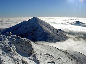
The mountain of Stob Binnein lies in the Loch Lomond and The Trossachs National Park.
Many parts of Scotland are protected in accordance with a number of national and international designations because of their environmental, historical or cultural value. Protected areas can be divided according to the type of resource which each seeks to protect. NatureScot has various roles in the delivery of many environmental designations in Scotland, i.e. those aimed at protecting flora and fauna, scenic qualities and geological features. Historic Environment Scotland is responsible for designations that protect sites of historic and cultural importance. Some international designations, such as World Heritage Sites, can cover both categories of site.
The various designations overlap considerably with many protected areas being covered by multiple designations with different boundaries. (Full article...) -
The state of Johor in Malaysia is noted for its national parks and forest reserves which preserve virgin rainforests known for its biodiversity and endangered species of animals.
Mangrove swamps and coral reefs are also protected within these parks. (Full article...) -
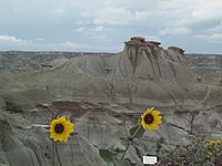
Dinosaur Provincial Park
This is a list of protected areas of Alberta. Protected areas are managed by the Government of Canada or the Government of Alberta. The provincial government owns 60% of Alberta's landmass but most of this has not been formally protected. The total protected area throughout Alberta including federal and provincial protected areas is approximately 90,700 km2 (35,000 sq mi). (Full article...) -
This is a list of protected areas of Sierra Leone, including national parks, game reserves, conservation areas, wetlands, and those that are listed as proposed protected areas in the UN Environment Programme World Conservation Monitoring Centre (UNEP WCM) database. (Full article...)
-

Vegetation outside Goz Beïda
The wildlife of Chad is composed of its flora and fauna. Bush elephants, West African lions, buffalo, hippopotamuses, Kordofan giraffes, antelopes, African leopards, cheetahs, hyenas, and many species of snakes are found there, although most large carnivore populations have been drastically reduced since the early 20th century. Elephant poaching, particularly in the south of the country in areas such as Zakouma National Park, is a severe problem. (Full article...) -

Cape Spencer Lighthouse, Innes National Park
Protected areas of South Australia, consisting of protected areas located within South Australia and its immediate onshore waters and which are managed by South Australian Government agencies. As of 2018, South Australia contained 359 separate protected areas declared under the National Parks and Wildlife Act 1972, the Crown Land Management Act 2009 and the Wilderness Protection Act 1992. Together, they cover a total land area of 211,387.48 km2 (81,617.16 sq mi) or 21.5% of the state's area. (Full article...)


Selected world maps
-
 Mollweide projection of the world
 -
 The world map by Gerardus Mercator (1569), the first map in the well-known Mercator projection
 -
 Only a few of the largest large igneous provinces appear (coloured dark purple) on this geological map, which depicts crustal geologic provinces as seen in seismic refraction data
 -
 Time zones of the world
 -
 1516 map of the world by Martin Waldseemüller
 -
 Index map from the International Map of the World (1:1,000,000 scale)
 -
 The Goode homolosine projection is a pseudocylindrical, equal-area, composite map projection used for world maps.
 -
 United Nations Human Development Index map by country (2016)
 -
 A plate tectonics map with volcano locations indicated with red circles


World records
- List of Olympic records in athletics
- List of world records in athletics
- List of junior world records in athletics
- List of world records in masters athletics
- List of world youth bests in athletics
- List of IPC world records in athletics
- List of world records in canoeing
- List of world records in chess
- List of cycling records
- List of world records in track cycling
- List of world records in finswimming
- List of world records in juggling
- List of world records in rowing
- List of world records in speed skating
- List of world records in swimming
- List of IPC world records in swimming
- List of world records in Olympic weightlifting
Topics

Continents of Earth | ||||||||
|---|---|---|---|---|---|---|---|---|
| ||||||||
| ||||||||
| ||||||||


| Cenozoic Era (present–66.0 Ma) |
| ||||||||||||
|---|---|---|---|---|---|---|---|---|---|---|---|---|---|
| Mesozoic Era (66.0–252 Ma) |
| ||||||||||||
| Paleozoic Era (252–539 Ma) |
| ||||||||||||
| Proterozoic Eon (539 Ma–2.5 Ga) |
| ||||||||||||
| Archean Eon (2.5–4 Ga) | |||||||||||||
| Hadean Eon (4–4.6 Ga) | |||||||||||||
ka = kiloannum (thousands years ago); Ma = megaannum (millions years ago); Ga = gigaannum (billions years ago). See also: Geologic time scale • | |||||||||||||
| Locations | ||
|---|---|---|
| Related | ||

| |||||||||||||||||||
| |||||||||||||||||||
| |||||||||||||||||||

Economic classification of countries | |||||
|---|---|---|---|---|---|
| Three-World Model | |||||
| Gross domestic product (GDP) |
| ||||
| Gross national income (GNI) | |||||
| Wages | |||||
| Wealth | |||||
| Other national accounts | |||||
| Human development | |||||
| Digital divide | |||||
| Net international investment position (NIIP) | |||||
| Technological |
| ||||
|---|---|---|---|---|---|
| Sociological | |||||
| Ecological |
| ||||
| Biological |
| ||||
| Astronomical | |||||
| Eschatological |
| ||||
| Others |
| ||||
| Fictional | |||||
| Organizations | |||||
Categories

Wikimedia
The following Wikimedia Foundation sister projects provide more on this subject:
-
 Commons
Free media repository -
 Wikibooks
Free textbooks and manuals -
 Wikidata
Free knowledge base -
 Wikinews
Free-content news -
 Wikiquote
Collection of quotations -
 Wikisource
Free-content library -
 Wikispecies
Directory of species -
 Wikiversity
Free learning tools -
 Wikivoyage
Free travel guide -
 Wiktionary
Dictionary and thesaurus


