
Portal:Kent/Sandbox
DesktopMobile
Test of: Transclude files as random slideshow/sandbox
-
 An early mention of Kent in the Anglo-Saxon Chronicle between 11th and 12th centuries (from Kent)
 -

-
 A map of Romney Marsh "The history of imbanking and drayning" by William Dugdale (1662). (from Kent)
 -

-
-
-
 View of the White Cliffs of Dover from France (from Kent)
 -

-
 Canterbury Cathedral (from Kent)
 -
 The White Cliffs of Dover (from Kent)
 -
-
 The coat of arms of Kent County Council (from Kent)
 -
 Geological cross-section of Kent, showing how it relates to major towns (from Kent)
 -
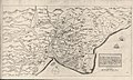
 Hand-drawn map of Kent, Sussex, Surrey and Middlesex from 1575. (from Kent)
 -
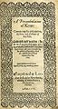 Title page of William Lambarde's Perambulation of Kent (completed in 1570 and published in 1576), a historical description of Kent and the first published county history (from Kent)

.jpg)


Apr2006.jpg)


Test of: Transclude linked excerpts as random slideshow/sandbox
-
 Cricket is a bat-and-ball game that is played between two teams of eleven players on a field at the centre of which is a 22-yard (20-metre) pitch with a wicket at each end, each comprising two bails balanced on three stumps. Two players from the batting team (the striker and nonstriker) stand in front of either wicket, with one player from the fielding team (the bowler) bowling the ball towards the striker's wicket from the opposite end of the pitch. The striker's goal is to hit the bowled ball and then switch places with the nonstriker, with the batting team scoring one run for each exchange. Runs are also scored when the ball reaches or crosses the boundary of the field or when the ball is bowled illegally. (Full article...)
 -
Thomas Tallis (c. 1505 – 23 November 1585; also Tallys or Talles) was an English composer of High Renaissance music. His compositions are primarily vocal, and he occupies a primary place in anthologies of English choral music. Tallis is considered one of England's greatest composers, and is honoured for his original voice in English musicianship. (Full article...)
-
Charles John Huffam Dickens (/ˈdɪkɪnz/; 7 February 1812 – 9 June 1870) was an English novelist and social critic who created some of the world's best-known fictional characters, and is regarded by many as the greatest novelist of the Victorian era. His works enjoyed unprecedented popularity during his lifetime and, by the 20th century, critics and scholars had recognised him as a literary genius. His novels and short stories are widely read today. (Full article...)
-
Gravesend /ˌɡreɪvzˈɛnd/ is a town in northwest Kent, England, situated 21 miles (35 km) east-southeast of Charing Cross (central London) on the south bank of the River Thames and opposite Tilbury in Essex. Located in the diocese of Rochester, it is the administrative centre of the borough of Gravesham. Gravesend marks the eastern limit of the Greater London Built-up Area, as defined by the UK Office for National Statistics. In 2021 it had a population of 58,102. (Full article...)
-
The Kingdom of the Kentish (Old English: Cantwara rīce; Latin: Regnum Cantuariorum), today referred to as the Kingdom of Kent, was an early medieval kingdom in what is now South East England. It existed from either the fifth or the sixth century AD until it was fully absorbed into the Kingdom of Wessex in the late 9th century and later into the Kingdom of England in the early 10th century. (Full article...)
-
The Hoo Peninsula is a peninsula in Kent, England, separating the estuaries of the rivers Thames and Medway. It is dominated by a line of chalk, clay and sand hills, surrounded by an extensive area of marshland composed of alluvial silt. The name Hoo is a Saxon word believed to mean 'spur of land' or refers to the 'distinct heel-shape of the ridge of hills' through Hoo. Hoo features in the Domesday Book. The peninsula is home to internationally and nationally protected wildlife sites as well as industrial facilities and energy industries. (Full article...)
-
The Men's England Hockey League is a field hockey league organised by England Hockey that features men's teams from England and Wales. (Full article...)
-
Manston Airport (IATA: MSE, ICAO: EGMH) was a British airport. Originally operated as RAF Manston, from 1918, it has also operated as a commercial airport and was known as Kent International Airport and, briefly, London Manston Airport. It has been closed since 2014. Located in the parish of Minster-in-Thanet and partly adjacent to the village of Manston in the Thanet district of Kent, England, 11 NM (20 km; 13 mi) north-east of Canterbury. (Full article...)
-
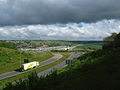
The Dartford–Thurrock River Crossing, commonly known as the Dartford Crossing and until 1991 the Dartford Tunnel, is a major road crossing of the River Thames in England, carrying the A282 road between Dartford in Kent in the south and Thurrock in Essex in the north. (Full article...)
-
South East England is one of the nine official regions of England in the United Kingdom at the first level of ITL for statistical purposes. It consists of the counties of Buckinghamshire, East Sussex, Hampshire, the Isle of Wight, Kent, Oxfordshire, Berkshire, Surrey and West Sussex. Major towns and cities in the region include Brighton and Hove, Canterbury, Milton Keynes, Southampton, Portsmouth, Slough, Reading and Oxford. (Full article...)
-
Kent is a county in the South East England region, the closest county to continental Europe. It borders Essex across the entire estuary of the River Thames to the north; the French department of Pas-de-Calais across the Strait of Dover to the south-east; East Sussex to the south-west; Surrey to the west and Greater London to the north-west. The county town is Maidstone. (Full article...)
-
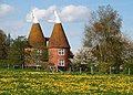
A windmill is a structure that converts wind power into rotational energy using vanes called sails or blades, by tradition specifically to mill grain (gristmills), but in some parts of the English-speaking world, the term has also been extended to encompass windpumps, wind turbines, and other applications. The term wind engine is also sometimes used to describe such devices. (Full article...)
-
Dover Athletic Football Club is a semi-professional association football club based in the town of Dover, Kent, England. The club currently competes in the National League South, the sixth tier of English football. The club was formed in 1983 after the dissolution of the town's previous club, Dover F.C., whose place in the Southern League was taken by the new club. (Full article...)
-
-
The following is a list of recreational walks in Kent, England. (Full article...)
-
Rupert Bear is an English children's comic strip character and franchise created by Herbert Tourtel and illustrated by his wife, the artist Mary Tourtel, first appearing in the Daily Express newspaper on 8 November 1920. Rupert's initial purpose was to win sales from the rival Daily Mail and Daily Mirror. In 1935, the stories were taken over by Alfred Bestall, who was previously an illustrator for Punch and other glossy magazines. Bestall proved to be successful in the field of children's literature and worked on Rupert stories and artwork into his nineties. More recently, various other artists and writers have continued the series. About 50 million copies have been sold worldwide. (Full article...)
-
The North Downs are a ridge of chalk hills in south east England that stretch from Farnham in Surrey to the White Cliffs of Dover in Kent. Much of the North Downs comprises two Areas of Outstanding Natural Beauty (AONBs): the Surrey Hills and the Kent Downs. The North Downs Way National Trail runs along the North Downs from Farnham to Dover. (Full article...)
-
Isle of Grain (Old English Greon, meaning gravel) is a village and the easternmost point of the Hoo Peninsula within the district of Medway in Kent, south-east England. No longer an island and now forming part of the peninsula, the area is almost all marshland and is a major habitat for diverse wetland birds. The village constitutes a civil parish, which at the 2011 census had a population of 1,648, a net decrease of 83 people in 10 years. (Full article...)
-
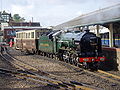
The East Kent Railway (EKR) is a heritage railway in Kent, England. It is located at Shepherdswell station on the London and Chatham to Dover mainline. The line was constructed between 1911 and 1917 to serve the Kent Coalfields. See East Kent Light Railway for details of the original lines. The Kent Collieries were mostly a failure with only Tilmanstone on the line producing any viable commercial coal and commercial traffic over the line.
The line is operated by heritage diesel locomotives. It is home to a collection of heritage diesel locomotives including a British Rail Class 08, DEMU and electric multiple units including an in service British Rail Class 404 built in the 1930s and a more modern British Rail Class 365, which is to be used as a restaurant and a major events venue. (Full article...) -
The 2007 Kent earthquake registered 4.3 on the Richter scale and struck south east Kent, South East England on 28 April 2007 at 07:18:12 UTC (08:18:12 local time), at a shallow depth of 5.3 km. (Full article...)
-
Maidstone Grammar School (MGS) is a grammar school in Maidstone, England. The school was founded in 1549 after Protector Somerset sold Corpus Christi Hall on behalf of King Edward VI to the people of Maidstone for £200. The Royal Charter for establishment of a grammar school was also granted at this time. (Full article...)
-
Dungeness (UK: /ˌdʌndʒəˈnɛs/) is a headland on the coast of Kent, England, formed largely of a shingle beach in the form of a cuspate foreland. It shelters a large area of low-lying land, Romney Marsh. Dungeness spans Dungeness Nuclear Power Station, the hamlet of Dungeness, and an ecological site at the same location. It lies within the civil parish of Lydd. (Full article...)
-
Folkestone and Hythe is a local government district in Kent, England. It lies in the south-east of the county, on the coast of the English Channel. The district was formed in 1974 and was originally named Shepway after one of the ancient lathes of Kent, which had covered a similar area. The district was renamed in 2018. The council is based in Folkestone, the district's largest town. The district also includes the towns of Hawkinge, Hythe, Lydd and New Romney, along with numerous villages and surrounding rural areas. (Full article...)
-
Thomas Sidney Cooper CVO RA (26 September 1803 – 7 February 1902) was an English landscape painter from Canterbury, noted for his images of cattle and farm animals. (Full article...)
