
Gariep Dam
| Gariep Dam | |
|---|---|
 Gariep Dam | |
 Location of Gariep Dam in South Africa | |
| Official name | Gariep Dam |
| Location | Border of Eastern Cape and Free State, South Africa |
| Coordinates | 30°37′25.43″S 25°30′23.81″E / 30.6237306°S 25.5066139°E |
| Construction began | 1965 |
| Opening date | 1971 |
| Owner(s) | Department of Water Affairs |
| Dam and spillways | |
| Type of dam | Arch-gravity dam |
| Impounds | Orange River |
| Height | 88 m (289 ft) |
| Length | 914 m (2,999 ft) |
| Reservoir | |
| Creates | Gariep Dam Reservoir |
| Total capacity | 5,340,000 megalitres (5,340 hm3; 5.34×10⁹ m3)[1] |
| Surface area | 374 km2 (144 sq mi) |
| Power Station | |
| Operator(s) | Eskom |
| Turbines | 4 x 90 MW (120,000 hp) |
| Installed capacity | 360 MW (480,000 hp) (max) |
| Annual generation | 889 GWh (3,200 TJ)[2] |
This article needs additional citations for verification. (July 2023) |
The Gariep Dam is located in South Africa, near the town of Norvalspont, bordering the Free State and Eastern Cape provinces. Its primary purpose is for irrigation, domestic and industrial use as well as for power generation. It the largest dam in South Africa.
Name[edit]
The Gariep Dam, at its commission in 1971, was originally named the Hendrik Verwoerd Dam after Hendrik Verwoerd, the Prime Minister before and after 31 May 1961, when the country changed from the Union of South Africa to the Republic of South Africa. However, after the end of apartheid, the Verwoerd name was considered unsuitable. The name was officially changed to Gariep Dam on 4 October 1996. Gariep is Khoekhoe for "river", the original name of the Orange River.[3]
Location[edit]
The dam is on the Orange River about 48 kilometres (30 mi) north-east of Colesberg and 208 kilometres (129 mi) south of Bloemfontein. It is in a gorge at the entrance to the Ruigte Valley some 5 kilometres (3.1 mi) east of Norvalspont. The dam crest is some 1300 m (4250 ft) above sea level.
Dimensions[edit]
The wall is 88 m high and has a crest length of 914 m and contains approximately 1.73 million m³ of concrete. The Gariep Dam is the largest storage reservoir in South Africa. In South African English, 'dam' refers both to the structure and the water volume it retains. Gariep Dam has a total storage capacity of approximately 5,340,000 megalitres (5,340 hm3) and a surface area of more than 370 square kilometres (140 sq mi) when full. The hydro-electrical power station houses four 90 MW generators.
Design type and contractors[edit]
The structure is a concrete gravity-arch hybrid dam. This design was chosen as the gorge is too wide for a complete arch so flanking walls form gravity abutments to the central arch.
It was built by Dumez, a French construction company.
Gariep Dam Bridge[edit]
Gariep Dam bridge | |
|---|---|
.jpg) | |
| Coordinates | 30°37′22″S 25°30′23″E / 30.6228°S 25.5064°E |
| Carries | 14300 tons |
| Characteristics | |
| Width | Doubleway |
| Statistics | |
| Toll | None |
| Location | |
 | |
Rivers and spruits flowing into the dam[edit]
- Orange River[4]
- Caledon River[4]
- Brakspruit[4]
- Broekspruit[4]
- Oudagspruit[4]
- Palmietspruit[4]
- Slykspruit[4]
Water consumption, outflow, derivative usages and diversions[edit]
It must be carefully managed by balancing the supply-and-demand of this water resource usage for its derivatives of electricity generation, irrigation(food) and municipal drinking water. There is trade off in the water usage for electricity and inter-basin transfer for water in other areas like Port Elizabeth.
Orange–Fish Water Scheme[edit]
The scheme diverts water from the Orange River to the Great Fish River valley.[5][6]
- Great Fish River Valley, then via Grassridge Dam, ElandsDrift Wier, Cookhouse Tunnel, De MistKraal Weir[7] into
- Sundays River Valley (Canals and Tunnels Scheme) North-West of Port Elizabeth, then via Darlington Dam, Korhaansdrift Weir, Canal, Scheepersvlakte Balancing Dam,[8] Bulk water Pipeline[9] to
- Port Elizabeth, Nooitgedracht Water Treatment Works,[10] since 1992 with water from the Sundays River Valley[11] (See External links for more video documentaries on construction and drone footage for canal system.)

Orange-Fish River Tunnel[edit]
At Oviston, on the south bank of the reservoir, is the inlet of the Orange-Fish River Tunnel, allowing water to be diverted to the Great Fish River and most of the Eastern Cape's western parts.
Gariep hydroelectric power plant[edit]
A 360 MW hydroelectric power plant is one is run by Eskom. Four 90 MW hydro turbines (which are remotely controlled from Gauteng)[12]
Gallery[edit]
-
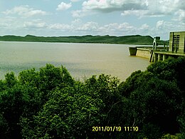
 Gariep Dam overflowing in January 2011
 -
 Sunset at Oviston Nature Reserve on the dam's southern shores
 -
 Road sign heading for the dam wall
 -
 View over the lake
 -
 Forever Holiday Resort at Gariep Dam


.JPG)
.JPG)
.JPG)
See also[edit]
References[edit]
- ^ "State of Dams in Provinces as on 20080901". Department of Water Affairs and Forestry. Archived from the original on 2008-04-21. Retrieved 2008-09-07.
- ^ Eskom website
- ^ "Dictionary of Southern African Place Names (Public Domain)". Human Science Research Council. p. 171.
- ^ a b c d e f g Dept of Water Affairs website
- ^ "FISH-SUNDAYS TRANSFER SCHEME". Archived from the original on 2021-09-03.
- ^ "Department of Water Affairs: Orange River Basin". Archived from the original on 2022-06-16.
- ^ https://www.gfrwua.com/orange-river-project Archived 2020-10-02 at the Wayback Machine | Great Fish River Water Users Association since 1920
- ^ https://www.gfrwua.com/orange-river-project Archived 2020-10-02 at the Wayback Machine Great Fish River Water Users Association since 1920
- ^ http://www.dwa.gov.za/orange/Mid_Orange/fish-sun.htm Archived 2021-08-17 at the Wayback Machine Department of Water - Fish-Sundays
- ^ Nooitgedracht Water Treatment Works - See External Links Documentary
- ^ "Map Illustration - Further details". Department of Water - Fish-Sundays. Archived from the original on 2021-08-17. Retrieved 2020-09-22.
- ^ "ESKOM'S HYDROELECTRIC POWER STATIONS – GARIEP AND VANDERKLOOF" (PDF).
External links[edit]
Videos - Opening | Documentaries | Construction[edit]
- Official Opening of the Orange River Dam in South Africa on YouTube
- Short Documentary on the dam construction and motivations thereof (1 of 3 planned dams) on YouTube
- History of the town Construction on YouTube
- Orange-Fish River Tunnel Basin Transfer Schema Construction 1972 - Technical illustrations & diagrams(Port Elizabeth) on YouTube
- Orange-Fish River Tunnel Basin Transfer Schema Construction - Footage on YouTube
- History of the construction and where it all started, rainfall, diagrams, extra
- Orange River Transfer Scheme to Port Elizabeth Documentary - Nooitgedracht Water Treatment Works on YouTube (Carte Blanche)
- The excavation of the Orange-Fish Tunnel
- ORANGE / FISH & LOWER SUNDAYS RIVERWATER SUPPLY SCHEMES
- Part 1 | From the towering inlet to the town that disappeared forever | Oviston to Midshaft
- Part 2 | The road that time simply forgot | The Bulhoek Pass
- Part 3 | Ghost town of empty houses and empty swimming pools | Teebus to The Outlet
Videos - Aerial | Presentation[edit]
- Full Flood over gates January 2000 on YouTube
- 4K Aerial footage of Dam, bridge, campsite, amenities on YouTube
- 4K Aerial footage not in flood on YouTube
Other[edit]
- Gariep Dam - Roots - Largest in the Country - Construction Posters, Origins and Designs from inside the dam wall
- Gariep Hydroelectric Power Station on the Eskom-Website
 Media related to Gariep Dam at Wikimedia Commons
Places adjacent to Gariep Dam | ||||||||||||||||
|---|---|---|---|---|---|---|---|---|---|---|---|---|---|---|---|---|
| ||||||||||||||||