Arboga River
| Arboga River | |
|---|---|
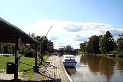
 The harbour of Kungsör, Arboga River | |
 | |
| Native name | Arbogaån (Swedish) |
| Location | |
| Country | Sweden |
| County | Örebro, Västmanland |
| Physical characteristics | |
| Source | Väringen |
| • coordinates | 59°25′30″N 15°26′05″E / 59.42500°N 15.43472°E |
| • elevation | 32 m (105 ft) |
| Mouth | Mälaren |
• location | Kungsör |
• coordinates | 59°25′50″N 16°06′15″E / 59.43056°N 16.10417°E |
• elevation | 0.7 m (2 ft 4 in) |
| Length | 145 km (90 mi)[1] |
| Basin size | 3,808 km2 (1,470 sq mi) |
| Discharge | |
| • average | 38 m3/s (1,300 cu ft/s)[1] |
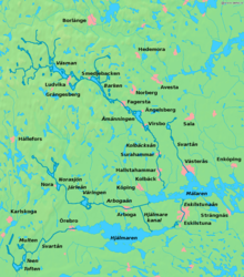
Arboga River (Swedish: Arbogaån) is a river in Sweden. It flows from the lake Väringen, through Arboga and eventually into the lake Mälaren at Kungsör.
References[edit]
- ^ a b "Arbogaån". Nationalencyklopedin (in Swedish). Retrieved 29 August 2010. (subscription required)

