
File:The situation in the Nagorno-Karabakh region during the peacekeeping operation as of December 13, 2020.jpg

Size of this preview: 800 × 450 pixels. Other resolutions: 320 × 180 pixels | 640 × 360 pixels | 1,024 × 576 pixels | 1,280 × 720 pixels | 2,800 × 1,575 pixels.
Original file (2,800 × 1,575 pixels, file size: 4.03 MB, MIME type: image/jpeg)
| This is a file from the Wikimedia Commons. Information from its description page there is shown below. Commons is a freely licensed media file repository. You can help. |
Summary
| Description |
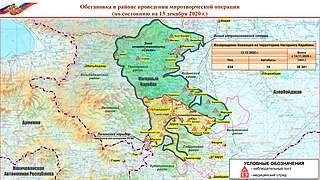
Русский: в сравнении с картой от 12 декабря 2020 года (File:The situation in the Nagorno-Karabakh region during the peacekeeping operation as of December 12, 2020.jpg произошло резкое расширение зоны контроля российских миротворцев на юг в окрестности села Хинтаглар |
| Date | |
| Source | [1] |
| Author | Минобороны России |
![[1]](http://mil.ru/files/morf/map_karabakh_13_12.jpg)
Licensing

|
This file comes from the websites (mil.ru, минобороны.рф) of the Ministry of Defence of the Russian Federation and is copyrighted.
This file is licenced under the Creative Commons Attribution 4.0 Licence. In short: you are free to distribute and modify the file as long as you attribute Mil.ru.
|
This file is licensed under the Creative Commons Attribution 4.0 International license.
Attribution: Mil.ru
- You are free:
- to share – to copy, distribute and transmit the work
- to remix – to adapt the work
- Under the following conditions:
- attribution – You must give appropriate credit, provide a link to the license, and indicate if changes were made. You may do so in any reasonable manner, but not in any way that suggests the licensor endorses you or your use.
File history
Click on a date/time to view the file as it appeared at that time.
| Date/Time | Thumbnail | Dimensions | User | Comment | |
|---|---|---|---|---|---|
| current | 16:51, 13 December 2020 | | 2,800 × 1,575 (4.03 MB) | Bogomolov.PL | Uploaded a work by Минобороны России from [http://mil.ru/files/morf/map_karabakh_13_12.jpg] with UploadWizard |
File usage
The following pages on the English Wikipedia use this file (pages on other projects are not listed):
Global file usage
The following other wikis use this file:
- Usage on ar.wikipedia.org
- Usage on de.wikipedia.org
- Usage on hy.wikipedia.org
- Usage on ru.wikipedia.org
- Usage on tr.wikipedia.org
- Usage on www.wikidata.org