
File:Terrestrial ecozones and ecoprovinces of Canada, 2017.gif

Size of this preview: 702 × 599 pixels. Other resolutions: 281 × 240 pixels | 562 × 480 pixels | 710 × 606 pixels.
Original file (710 × 606 pixels, file size: 122 KB, MIME type: image/gif)
| This is a file from the Wikimedia Commons. Information from its description page there is shown below. Commons is a freely licensed media file repository. You can help. |
Summary
| Description |
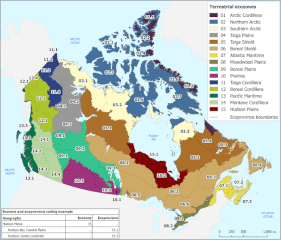
English: The title of this map is “Terrestrial ecozones and ecoprovinces of Canada.” This map outlines the boundaries of the 15 ecozones and 53 ecoprovinces of Canada. These ecological areas cover all of the area within the coastal boundaries of Canada.
On this map, a solid grey line is used to define the ecozone and ecoprovince boundaries. Each ecozone is identified with a unique colour. Ecoprovinces are subdivisions of ecozones and are identified with a unique numeric code, the first two numbers of the ecoprovince code indicates the ecozone. Ecoprovinces numbered 01.1 and 01.2 belong to the Arctic Cordillera ecozone, code 01, and are coloured purple. Ecoprovinces numbered 02.1 through 02.7 belong to the Northern Arctic ecozone, code 02, and are coloured blue. Ecoprovinces 03.1 through 03.3 belong to the Southern Arctic ecozone, code 03, and are coloured pale yellow. Ecoprovinces 04.1 through 04.3 belong to the Taiga Plains ecozone, code 04, and are coloured grey. Ecoprovinces 05.1 through 05.4 belong to the Taiga Shield ecozone, code 05, and are coloured brown. Ecoprovinces 06.1 through 06.6 belong to the Boreal Shield ecozone, code 06, and are coloured light brown. Ecoprovinces numbered 07.1 through 07.3 belong to the Atlantic Maritime ecozone, code 07, and are coloured yellow. Ecoprovinces numbered 08.1 and 08.2 belong to the Mixedwood Plains ecozone, code 08, and are coloured olive green. Ecoprovinces numbered 09.1 through 09.3 belong to the Boreal Plains ecozone, code 09, and are coloured mint green. Ecoprovinces numbered 10.1 through 10.3 belong to the Prairies ecozone, code 10, and are coloured pink. Ecoprovinces numbered 11.1 through 11.4 belong to the Taiga Cordillera ecozone, code 11, and are coloured dark blue. Ecoprovinces 12.1 through 12.4 belong to the Boreal Cordillera ecozone, code 12, and are coloured lime green. Ecoprovinces numbered 13.1 through 13.3 belong to the Pacific Maritime ecozone, code 13, and are coloured dark green. Ecoprovinces 14.1 through 14.4 belong to the Montane Cordillera ecozone, code 14, and are coloured light green. Ecoprovinces 15.1 and 15.2 belong to the Hudson Plains ecozone, code 15, are coloured red. Land areas outside of Canada are coloured light grey. Water is pale blue and major bodies, like oceans and bays, are named. |
| Date | |
| Source | https://www.statcan.gc.ca/eng/subjects/standard/environment/elc/2017-map |
| Author | Statistics Canada |
| Permission (Reusing this file) |
https://www.statcan.gc.ca/en/reference/licence |
Licensing
.svg) |
This file is licensed under the Statistics Canada Open Licence. |
| |
File history
Click on a date/time to view the file as it appeared at that time.
| Date/Time | Thumbnail | Dimensions | User | Comment | |
|---|---|---|---|---|---|
| current | 09:15, 7 November 2020 | | 710 × 606 (122 KB) | Ponderosapine210 | Uploaded a work by Statistics Canada from https://www.statcan.gc.ca/eng/subjects/standard/environment/elc/2017-map with UploadWizard |
File usage
The following pages on the English Wikipedia use this file (pages on other projects are not listed):
Global file usage
The following other wikis use this file:
- Usage on de.wikipedia.org
- Usage on lt.wikipedia.org
- Usage on ru.wikipedia.org