
File:Map of occupation zones on Crete April 1898.JPG
No higher resolution available.
Map_of_occupation_zones_on_Crete_April_1898.JPG (779 × 348 pixels, file size: 36 KB, MIME type: image/jpeg)
| This is a file from the Wikimedia Commons. Information from its description page there is shown below. Commons is a freely licensed media file repository. You can help. |
| Description |
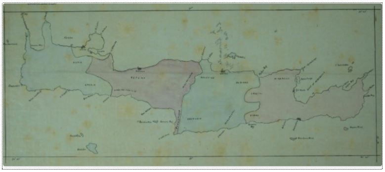
English: Major General Herbert Chermside′s (1850–1929) map of Crete showing zones of occupation and blockade responsibilities for the four remaining countries participating in the 1897-1898 intervention there via the International Squadron after the withdrawal of Austria-Hungary and the German Empire. Zones are, left to right, those of Italy, the Russian Empire, the United Kingdom, and France. Canea and Suda Bay remained under the international control of all four countries. |
| Date | |
| Source | The British in Crete, 1896 to 1913: Dividing Crete |
| Author | Unattributed |
This media file is in the public domain in the United States. This applies to U.S. works where the copyright has expired, often because its first publication occurred prior to January 1, 1929, and if not then due to lack of notice or renewal. See this page for further explanation.
|
 | |
 |
This image might not be in the public domain outside of the United States; this especially applies in the countries and areas that do not apply the rule of the shorter term for US works, such as Canada, Mainland China (not Hong Kong or Macao), Germany, Mexico, and Switzerland. The creator and year of publication are essential information and must be provided. See Wikipedia:Public domain and Wikipedia:Copyrights for more details.
|
|
This work is in the public domain in its country of origin and other countries and areas where the copyright term is the author's life plus 80 years or fewer.
| |
| This file has been identified as being free of known restrictions under copyright law, including all related and neighboring rights. | |
File history
Click on a date/time to view the file as it appeared at that time.
| Date/Time | Thumbnail | Dimensions | User | Comment | |
|---|---|---|---|---|---|
| current | 01:31, 7 January 2018 | | 779 × 348 (36 KB) | Mdnavman | {{Information |Description = Major General Herbert Chermside′s (1850–1929) map of Crete showing zones of occupation and blockade responsibilities for the four remaining countries participating in the 1897-1898 intervention there via the... |
File usage
The following pages on the English Wikipedia use this file (pages on other projects are not listed):
Global file usage
The following other wikis use this file:
- Usage on fr.wikipedia.org