
File:Former Yugoslavia 1991-1995.svg

Size of this PNG preview of this SVG file: 800 × 499 pixels. Other resolutions: 320 × 199 pixels | 640 × 399 pixels | 1,024 × 638 pixels | 1,280 × 798 pixels | 2,560 × 1,596 pixels | 1,832 × 1,142 pixels.
Original file (SVG file, nominally 1,832 × 1,142 pixels, file size: 108 KB)
| This is a file from the Wikimedia Commons. Information from its description page there is shown below. Commons is a freely licensed media file repository. You can help. |
Summary
| Description |
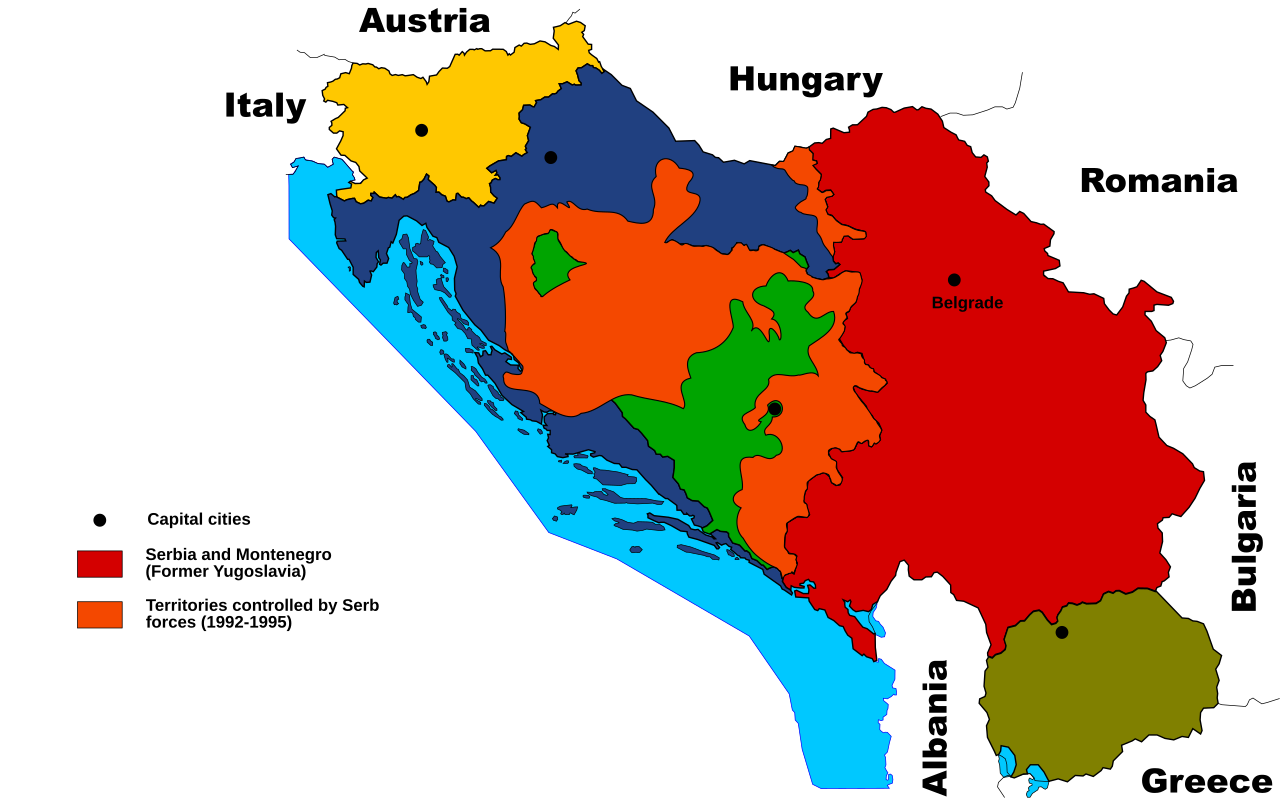
English: Territories of the Republic of Bosnia and Herzegovina and the Republic of Croatia controlled by the Serb forces, after the Operation Corridor (July 1992) in the Yugoslav Wars.
According to the prosecution of War Crimes Tribunal, "Serbian forces" included Yugoslav Army, Serb Territorial Defense of Bosnia and Herzegovina and Croatia, Republic of Srpska Krajina Army, Army of the Republika Srpska, territorial defense of Serbia and Montenegro, Police of Serbia and Police of Republika Srpska, including national security, special police forces of Krajina known as "Martićevci", as well as all Serbian paramilitary forces and volunteer units.[1] Croatia declared independence on June 25, 1991. It was internationally recognized on 15 January 1992 by the United Nations. Bosnia and Herzegovina declared independence on March 5 1992. It was internationally recognized on 22 May 1992 by the United Nations. Serbia and Montenegro proclaimed FR Yugoslavia as a sole successor state of SFR Yugoslavia, on April 27 1992. It remained unrecognized during the conflict (1991-1995). |
| Date | (UTC) |
| Source | |
| Author |
|
| This is a retouched picture, which means that it has been digitally altered from its original version. Modifications: used it as a base for another map. The original can be viewed here: Former Yugoslavia 2006.svg:
|
Licensing
I, the copyright holder of this work, hereby publish it under the following licenses:
| This file is licensed under the Creative Commons Attribution-Share Alike 3.0 Unported license. | ||
| ||
| This licensing tag was added to this file as part of the GFDL licensing update. |

|
Permission is granted to copy, distribute and/or modify this document under the terms of the GNU Free Documentation License, Version 1.2 or any later version published by the Free Software Foundation; with no Invariant Sections, no Front-Cover Texts, and no Back-Cover Texts. A copy of the license is included in the section entitled GNU Free Documentation License. |
You may select the license of your choice.
Original upload log
This image is a derivative work of the following images:
- File:Former_Yugoslavia_2006.svg licensed with Cc-by-sa-3.0-migrated, GFDL
- 2006-06-26T11:27:02Z Shazz 1832x1142 (631450 Bytes) ==Authors:== *Based on bitmap by: Paweł Goleniowski [[w:pl:swPawel|swPawel]] *SVG by: ** commons: [[user:Shazz|Shazz]] ** pl.wiki: [[w:pl:user:Shazz|Shazz]] ==Description== * '''pl:''' Mapa byłej Jugosławii, z uwzględnie
- 2006-06-21T08:53:03Z Shazz 1832x1142 (628037 Bytes) ==Authors:== *Based on bitmap by: [[w:pl:swPawel|swPawel]] *SVG by: ** commons: [[user:Shazz|Shazz]] ** pl.wiki: [[w:pl:user:Shazz|Shazz]] ==Description== * '''pl:''' Mapa byłej Jugosławii, z uwzględnieniem podziału Serb
Uploaded with derivativeFX
- ↑ Šešelj ICTY Case information sheet (retrieved 10.07.2009.)
File history
Click on a date/time to view the file as it appeared at that time.
| Date/Time | Thumbnail | Dimensions | User | Comment | |
|---|---|---|---|---|---|
| current | 14:09, 2 November 2011 | | 1,832 × 1,142 (108 KB) | Citypeek | Changed the the name of the capital of Serbia |
| 13:53, 2 November 2011 |  | 1,832 × 1,142 (108 KB) | Citypeek | minor changes | |
| 21:33, 17 October 2011 |  | 1,832 × 1,142 (113 KB) | Citypeek | border added to East-Croatia. | |
| 15:34, 17 October 2011 |  | 1,832 × 1,142 (115 KB) | Citypeek | made a few changed as requested | |
| 06:02, 17 October 2011 |  | 1,832 × 1,142 (117 KB) | Citypeek | changed colors. | |
| 12:36, 16 October 2011 |  | 1,832 × 1,142 (117 KB) | Citypeek | Improvements and correction of errors | |
| 17:16, 14 October 2011 |  | 1,832 × 1,142 (152 KB) | Citypeek | == {{int:filedesc}} == {{Information |Description=*Based on bitmap by: Paweł Goleniowski swPawel *SVG by: ** commons: Shazz ** pl.wiki: Shazz == |Source=*File:Former_Yugoslavia_2006.svg |Date=201 |
File usage
The following pages on the English Wikipedia use this file (pages on other projects are not listed):
Global file usage
The following other wikis use this file:
- Usage on mk.wikipedia.org
- Usage on sh.wikipedia.org
- Usage on sr.wikipedia.org